Przygodzice geodata
Przygodzice (Greater Poland) is a seat of a third-order administrative division; located in Poland in Europe/Warsaw (GMT+2) time zone. With population of 3,000 people, there are 1040 cities with bigger population in this country. Compared to other cities in Poland, 57.7% of cities are located further ↓South; 76.9% of cities are located further →East and 61.5% of cities have higher elevation than Przygodzice. Note1


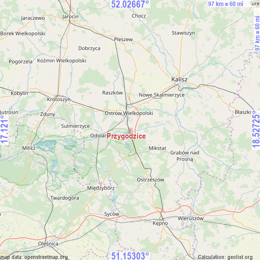
Przygodzice GPS coordinates[2]
51° 35' 31.02" North, 17° 49' 26.832" East
| Map corner | latitude | longitude |
|---|---|---|
| Upper-left | 52.02667°, | 17.121° |
| Center: | 51.59195°, | 17.82412° |
| Lower-right: | 51.15303°, | 18.52725° |
| Map W x H: | 97.1×97.1 km | = 60.3×60.3mi |
| max Lat: | 54.83135° ⇑42.3% North |
| Przygodzice: | 51.59195° |
| min Lat: | ⇓57.7% South 49.21328° |
| min Long | Przygodzice | max Long |
| 14.20249° | 17.82412° | 24.03723° |
| W 23.1%⇐ | ⇒76.9% E |
Elevation
Elevation of Przygodzice is 143 m = 469 ft, and this is 48.4 m = 159 ft below average elevation for this country.
| Max E: |
974 m = 3196 ft | 61.5% |
| Avg. | 191.4 m = 628 ft | |
| Przygodzice | 143 m = 469 ft | |
Min E: |
-3 m = -10 ft | 38.5% |
See also: Poland elevation on elevation.city.
Geographical zone
Przygodzice is located in North temperate zone (between Tropic of Cancer and the Arctic Circle). Distance of this North polar circle is 1664.7 km =1034.4 mi to North.| Distance of | km | miles | from Przygodzice |
|---|---|---|---|
| North Pole | 4270.6 | 2653.6 | to North |
| Arctic Circle | 1664.7 | 1034.4 | to North |
| Tropic Cancer | 3130.6 | 1945.3 | to South |
| Equator | 5736.5 | 3564.5 | to South |


Nearby cities:
15 places around Przygodzice: (largest is in red/bold)
• Garki
13.9 km =8.6 mi,  244°
244°
• Gorzyce Wielkie
8.2 km =5.1 mi,  307°
307°
• Janków Przygodzki
2.6 km =1.6 mi,  285°
285°
• Mikstat
12.3 km =7.6 mi,  122°
122°
• Moszczanka
15.3 km =9.5 mi,  337°
337°
• Nowe Skalmierzyce
17.6 km =10.9 mi,  41°
41°
• Odolanów
10.5 km =6.5 mi,  259°
259°
• Ostrów Wielkopolski
7.1 km =4.4 mi,  350°
350°
• Przybysławice
14.8 km =9.2 mi,  328°
328°
• Psary
14.9 km =9.3 mi,  60°
60°
• Raszków
15.6 km =9.7 mi, 334°
• Sieroszewice
11.2 km =7 mi,  65°
65°
• Skalmierzyce
15.5 km =9.6 mi, 38°
• Sośnie
18.6 km =11.6 mi,  224°
224°
• Wierzbno
11.9 km =7.4 mi,  295°
295°
Sources, notices
• [Note1] Compared only with cities in Poland existing in our database
• [Src1] Map data: © OpenStreetMap contributors (CC-BY-SA)
• [Src2] Other city data from geonames.org with taken over terms of usage.
• [Src3] Geographical zone / Annual Mean Temperature by Robert A. Rohde @ Wikipedia
