Siedlec geodata
Siedlec (Silesia) is a populated place; located in Poland in Europe/Warsaw (GMT+2) time zone. With population of 506 people, there are 3526 cities with bigger population in this country. Compared to other cities in Poland, 62.8% of cities are located further ↑North; 53.2% of cities are located further →East and 92.2% of cities have lower elevation than Siedlec. Note1


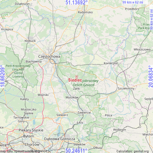
Siedlec GPS coordinates[2]
50° 41' 37.068" North, 19° 21' 54.756" East
| Map corner | latitude | longitude |
|---|---|---|
| Upper-left | 51.13692°, | 18.66209° |
| Center: | 50.69363°, | 19.36521° |
| Lower-right: | 50.24611°, | 20.06834° |
| Map W x H: | 99×99 km | = 61.5×61.5mi |
| max Lat: | 54.83135° ⇑62.8% North |
| Siedlec: | 50.69363° |
| min Lat: | ⇓37.2% South 49.21328° |
| min Long | Siedlec | max Long |
| 14.20249° | 19.36521° | 24.03723° |
| W 46.8%⇐ | ⇒53.2% E |
Elevation
Elevation of Siedlec is 360 m = 1181 ft, and this is 168.6 m = 553 ft above average elevation for this country.
| Max E: |
974 m = 3196 ft | 7.8% |
| Siedlec | 360 m 1181 ft | |
| Avg. | 191.4 m = 628 ft | |
Min E: |
-3 m = -10 ft | 92.2% |
See also: Poland elevation on elevation.city.
Geographical zone
Siedlec is located in North temperate zone (between Tropic of Cancer and the Arctic Circle). Distance of this North polar circle is 1764.6 km =1096.5 mi to North.| Distance of | km | miles | from Siedlec |
|---|---|---|---|
| North Pole | 4370.5 | 2715.7 | to North |
| Arctic Circle | 1764.6 | 1096.5 | to North |
| Tropic Cancer | 3030.7 | 1883.2 | to South |
| Equator | 5636.6 | 3502.4 | to South |


Nearby cities:
15 places around Siedlec: (largest is in red/bold)
• Choroń
7.5 km =4.7 mi,  259°
259°
• Dąbrowno
12.6 km =7.8 mi,  101°
101°
• Janów
5.8 km =3.6 mi,  55°
55°
• Jastrząb
13.2 km =8.2 mi, 258°
• Jaworznik
9.9 km =6.2 mi,  162°
162°
• Lgota Górna
13.5 km =8.4 mi,  219°
219°
• Myszków
13.5 km =8.4 mi,  192°
192°
• Niegowa
10.2 km =6.3 mi,  124°
124°
• Olsztyn
9.5 km =5.9 mi,  313°
313°
• Poraj
10.7 km =6.6 mi, 260°
• Potok Złoty
4.9 km =3 mi,  72°
72°
• Przybynów
5.6 km =3.5 mi, 216°
• Wysoka Lelowska
6.7 km =4.2 mi,  196°
196°
• Żarki
7.6 km =4.7 mi,  180°
180°
• Żarki-Letnisko
10.1 km =6.3 mi, 218°
Sources, notices
• [Note1] Compared only with cities in Poland existing in our database
• [Src1] Map data: © OpenStreetMap contributors (CC-BY-SA)
• [Src2] Other city data from geonames.org with taken over terms of usage.
• [Src3] Geographical zone / Annual Mean Temperature by Robert A. Rohde @ Wikipedia
