Rogowo geodata
Rogowo (Kujawsko-Pomorskie) is a seat of a third-order administrative division; located in Poland in Europe/Warsaw (GMT+2) time zone. With population of 2,127 people, there are 1398 cities with bigger population in this country. Compared to other cities in Poland, 79.7% of cities are located further ↓South; 78.8% of cities are located further →East and 81.8% of cities have higher elevation than Rogowo. Note1


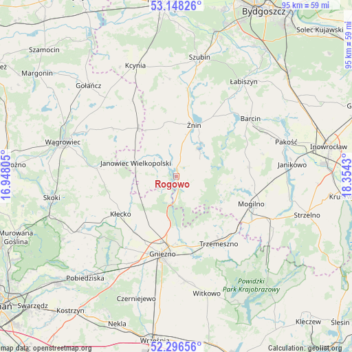
Rogowo GPS coordinates[2]
52° 43' 28.164" North, 17° 39' 4.212" East
| Map corner | latitude | longitude |
|---|---|---|
| Upper-left | 53.14826°, | 16.94805° |
| Center: | 52.72449°, | 17.65117° |
| Lower-right: | 52.29656°, | 18.3543° |
| Map W x H: | 94.7×94.7 km | = 58.8×58.8mi |
| max Lat: | 54.83135° ⇑20.3% North |
| Rogowo: | 52.72449° |
| min Lat: | ⇓79.7% South 49.21328° |
| min Long | Rogowo | max Long |
| 14.20249° | 17.65117° | 24.03723° |
| W 21.2%⇐ | ⇒78.8% E |
Elevation
Elevation of Rogowo is 96 m = 315 ft, and this is 95.4 m = 313 ft below average elevation for this country.
| Max E: |
974 m = 3196 ft | 81.8% |
| Avg. | 191.4 m = 628 ft | |
| Rogowo | 96 m = 315 ft | |
Min E: |
-3 m = -10 ft | 18.2% |
See also: Poland elevation on elevation.city.
Geographical zone
Rogowo is located in North temperate zone (between Tropic of Cancer and the Arctic Circle). Distance of this North polar circle is 1538.8 km =956.2 mi to North.| Distance of | km | miles | from Rogowo |
|---|---|---|---|
| North Pole | 4144.6 | 2575.3 | to North |
| Arctic Circle | 1538.8 | 956.2 | to North |
| Tropic Cancer | 3256.5 | 2023.5 | to South |
| Equator | 5862.4 | 3642.7 | to South |


Nearby cities:
15 places around Rogowo: (largest is in red/bold)
• Brzyskorzystewko
18.9 km =11.7 mi,  8°
8°
• Damasławek
16.3 km =10.1 mi,  321°
321°
• Dąbrowa
19.8 km =12.3 mi,  82°
82°
• Gniezno
21.6 km =13.4 mi,  192°
192°
• Gąsawa
8.5 km =5.3 mi,  55°
55°
• Janowiec Wielkopolski
11.4 km =7.1 mi,  287°
287°
• Krotoszyn
24.7 km =15.3 mi, 56°
• Kłecko
18.1 km =11.2 mi,  235°
235°
• Mieleszyn
12.1 km =7.5 mi, 239°
• Mieścisko
21.6 km =13.4 mi,  275°
275°
• Mogilno
21.8 km =13.5 mi,  109°
109°
• Sarbinowo
14.1 km =8.8 mi,  4°
4°
• Trzemeszno
21.5 km =13.4 mi,  147°
147°
• Wapno
23.6 km =14.7 mi,  329°
329°
• Żnin
14.7 km =9.1 mi,  18°
18°
Sources, notices
• [Note1] Compared only with cities in Poland existing in our database
• [Src1] Map data: © OpenStreetMap contributors (CC-BY-SA)
• [Src2] Other city data from geonames.org with taken over terms of usage.
• [Src3] Geographical zone / Annual Mean Temperature by Robert A. Rohde @ Wikipedia
