Trzemeszno geodata
Trzemeszno (Greater Poland) is a seat of a third-order administrative division; located in Poland in Europe/Warsaw (GMT+2) time zone. With population of 7,840 people, there are 511 cities with bigger population in this country. Compared to other cities in Poland, 77.3% of cities are located further ↓South; 76.9% of cities are located further →East and 76.4% of cities have higher elevation than Trzemeszno. Note1
Administrative division(s):
- Level 1: Greater Poland
- Level 2: Powiat gnieźnieński
- Level 3: Trzemeszno


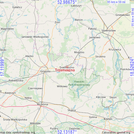
Trzemeszno GPS coordinates[2]
52° 33' 41.004" North, 17° 49' 23.196" East
| Map corner | latitude | longitude |
|---|---|---|
| Upper-left | 52.98675°, | 17.11999° |
| Center: | 52.56139°, | 17.82311° |
| Lower-right: | 52.13187°, | 18.52624° |
| Map W x H: | 95.1×95.1 km | = 59.1×59.1mi |
| max Lat: | 54.83135° ⇑22.7% North |
| Trzemeszno: | 52.56139° |
| min Lat: | ⇓77.3% South 49.21328° |
| min Long | Trzemeszno | max Long |
| 14.20249° | 17.82311° | 24.03723° |
| W 23.1%⇐ | ⇒76.9% E |
Elevation
Elevation of Trzemeszno is 107 m = 351 ft, and this is 84.4 m = 277 ft below average elevation for this country.
| Max E: |
974 m = 3196 ft | 76.4% |
| Avg. | 191.4 m = 628 ft | |
| Trzemeszno | 107 m = 351 ft | |
Min E: |
-3 m = -10 ft | 23.6% |
See also: Poland elevation on elevation.city.
Geographical zone
Trzemeszno is located in North temperate zone (between Tropic of Cancer and the Arctic Circle). Distance of this North polar circle is 1556.9 km =967.4 mi to North.| Distance of | km | miles | from Trzemeszno |
|---|---|---|---|
| North Pole | 4162.8 | 2586.6 | to North |
| Arctic Circle | 1556.9 | 967.4 | to North |
| Tropic Cancer | 3238.4 | 2012.2 | to South |
| Equator | 5844.3 | 3631.5 | to South |


Nearby cities:
15 places around Trzemeszno: (largest is in red/bold)
• Dąbrowa
22.1 km =13.7 mi,  21°
21°
• Gniezno
16.5 km =10.3 mi,  259°
259°
• Gąsawa
23.4 km =14.5 mi,  348°
348°
• Mieleszyn
25 km =15.5 mi,  298°
298°
• Mogilno
14 km =8.7 mi,  39°
39°
• Niechanowo
14.5 km =9 mi,  222°
222°
• Orchowo
14.3 km =8.9 mi,  113°
113°
• Ostrowite
25 km =15.5 mi,  143°
143°
• Powidz
17.7 km =11 mi,  158°
158°
• Rogowo
21.5 km =13.4 mi,  327°
327°
• Strzelno
24.7 km =15.3 mi,  72°
72°
• Wilczogóra
25.3 km =15.7 mi, 112°
• Wilczyn
24.3 km =15.1 mi, 109°
• Witkowo
14 km =8.7 mi,  194°
194°
• Łubowo
25.6 km =15.9 mi, 257°
Sources, notices
• [Note1] Compared only with cities in Poland existing in our database
• [Src1] Map data: © OpenStreetMap contributors (CC-BY-SA)
• [Src2] Other city data from geonames.org with taken over terms of usage.
• [Src3] Geographical zone / Annual Mean Temperature by Robert A. Rohde @ Wikipedia
