Malechowo geodata
Malechowo (West Pomerania) is a populated place; located in Poland in Europe/Warsaw (GMT+2) time zone. With population of 589 people, there are 3316 cities with bigger population in this country. Compared to other cities in Poland, 97.6% of cities are located further ↓South; 89.5% of cities are located further →East and 95.7% of cities have higher elevation than Malechowo. Note1


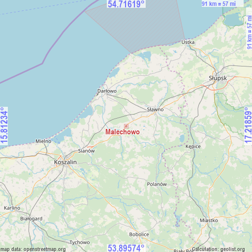
Malechowo GPS coordinates[2]
54° 18' 28.836" North, 16° 30' 55.656" East
| Map corner | latitude | longitude |
|---|---|---|
| Upper-left | 54.71619°, | 15.81234° |
| Center: | 54.30801°, | 16.51546° |
| Lower-right: | 53.89574°, | 17.21859° |
| Map W x H: | 91.2×91.2 km | = 56.7×56.7mi |
| max Lat: | 54.83135° ⇑2.4% North |
| Malechowo: | 54.30801° |
| min Lat: | ⇓97.6% South 49.21328° |
| min Long | Malechowo | max Long |
| 14.20249° | 16.51546° | 24.03723° |
| W 10.5%⇐ | ⇒89.5% E |
Elevation
Elevation of Malechowo is 34 m = 112 ft, and this is 157.4 m = 516 ft below average elevation for this country.
| Max E: |
974 m = 3196 ft | 95.7% |
| Avg. | 191.4 m = 628 ft | |
| Malechowo | 34 m = 112 ft | |
Min E: |
-3 m = -10 ft | 4.3% |
See also: Poland elevation on elevation.city.
Geographical zone
Malechowo is located in North temperate zone (between Tropic of Cancer and the Arctic Circle). Distance of this North polar circle is 1362.7 km =846.7 mi to North.| Distance of | km | miles | from Malechowo |
|---|---|---|---|
| North Pole | 3968.6 | 2466 | to North |
| Arctic Circle | 1362.7 | 846.7 | to North |
| Tropic Cancer | 3432.6 | 2132.9 | to South |
| Equator | 6038.5 | 3752.1 | to South |


Nearby cities:
15 places around Malechowo: (largest is in red/bold)
• Barcino
29.2 km =18.1 mi,  96°
96°
• Biesiekierz
36.6 km =22.7 mi,  237°
237°
• Będzino
35.8 km =22.2 mi,  252°
252°
• Darłowo
14.3 km =8.9 mi,  331°
331°
• Jamno
23.5 km =14.6 mi, 252°
• Kobylnica
34.5 km =21.4 mi,  64°
64°
• Koszalin
25.6 km =15.9 mi, 240°
• Kępice
25.4 km =15.8 mi,  107°
107°
• Manowo
24.6 km =15.3 mi,  214°
214°
• Mielno
29.9 km =18.6 mi,  259°
259°
• Ostrowiec
10.7 km =6.6 mi, 109°
• Polanów
23.7 km =14.7 mi,  152°
152°
• Postomino
24.3 km =15.1 mi,  31°
31°
• Sianów
17.2 km =10.7 mi, 238°
• Sławno
12.2 km =7.6 mi, 60°
Sources, notices
• [Note1] Compared only with cities in Poland existing in our database
• [Src1] Map data: © OpenStreetMap contributors (CC-BY-SA)
• [Src2] Other city data from geonames.org with taken over terms of usage.
• [Src3] Geographical zone / Annual Mean Temperature by Robert A. Rohde @ Wikipedia
