Polanów geodata
Polanów (West Pomerania) is a seat of a third-order administrative division; located in Poland in Europe/Warsaw (GMT+2) time zone. With population of 2,960 people, there are 1068 cities with bigger population in this country. Compared to other cities in Poland, 95.5% of cities are located further ↓South; 88.1% of cities are located further →East and 88.9% of cities have higher elevation than Polanów. Note1


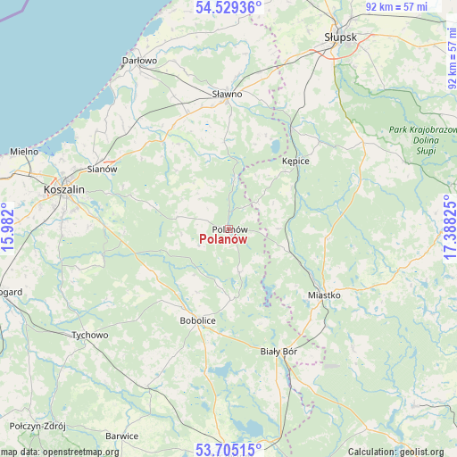
Polanów GPS coordinates[2]
54° 7' 9.48" North, 16° 41' 6.432" East
| Map corner | latitude | longitude |
|---|---|---|
| Upper-left | 54.52936°, | 15.982° |
| Center: | 54.1193°, | 16.68512° |
| Lower-right: | 53.70515°, | 17.38825° |
| Map W x H: | 91.6×91.6 km | = 56.9×56.9mi |
| max Lat: | 54.83135° ⇑4.5% North |
| Polanów: | 54.1193° |
| min Lat: | ⇓95.5% South 49.21328° |
| min Long | Polanów | max Long |
| 14.20249° | 16.68512° | 24.03723° |
| W 11.9%⇐ | ⇒88.1% E |
Elevation
Elevation of Polanów is 79 m = 259 ft, and this is 112.4 m = 369 ft below average elevation for this country.
| Max E: |
974 m = 3196 ft | 88.9% |
| Avg. | 191.4 m = 628 ft | |
| Polanów | 79 m = 259 ft | |
Min E: |
-3 m = -10 ft | 11.1% |
See also: Poland elevation on elevation.city.
Geographical zone
Polanów is located in North temperate zone (between Tropic of Cancer and the Arctic Circle). Distance of this North polar circle is 1383.7 km =859.8 mi to North.| Distance of | km | miles | from Polanów |
|---|---|---|---|
| North Pole | 3989.6 | 2479 | to North |
| Arctic Circle | 1383.7 | 859.8 | to North |
| Tropic Cancer | 3411.6 | 2119.9 | to South |
| Equator | 6017.5 | 3739.1 | to South |


Nearby cities:
15 places around Polanów: (largest is in red/bold)
• Barcino
25.2 km =15.7 mi,  45°
45°
• Biały Bór
26.6 km =16.5 mi,  158°
158°
• Bobolice
19.3 km =12 mi,  198°
198°
• Grzmiąca
35.4 km =22 mi,  207°
207°
• Koczała
34.5 km =21.4 mi,  133°
133°
• Koszalin
34.4 km =21.4 mi,  284°
284°
• Kępice
19 km =11.8 mi,  44°
44°
• Malechowo
23.7 km =14.7 mi,  332°
332°
• Manowo
25 km =15.5 mi,  271°
271°
• Miastko
23.3 km =14.5 mi,  123°
123°
• Ostrowiec
17.4 km =10.8 mi,  356°
356°
• Sianów
28.3 km =17.6 mi,  294°
294°
• Sławno
27.1 km =16.8 mi, 359°
• Trzebielino
27.7 km =17.2 mi,  71°
71°
• Tychowo
35.1 km =21.8 mi,  232°
232°
Sources, notices
• [Note1] Compared only with cities in Poland existing in our database
• [Src1] Map data: © OpenStreetMap contributors (CC-BY-SA)
• [Src2] Other city data from geonames.org with taken over terms of usage.
• [Src3] Geographical zone / Annual Mean Temperature by Robert A. Rohde @ Wikipedia
