Darłowo geodata
Darłowo (West Pomerania) is a populated place; located in Poland in Europe/Warsaw (GMT+2) time zone. With population of 14,398 people, there are 348 cities with bigger population in this country. Compared to other cities in Poland, 98.4% of cities are located further ↓South; 90% of cities are located further →East and 98.7% of cities have higher elevation than Darłowo. Note1


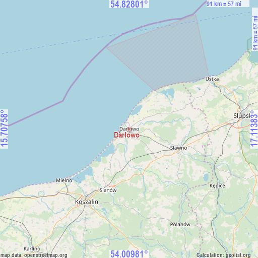
Darłowo GPS coordinates[2]
54° 25' 15.42" North, 16° 24' 38.52" East
| Map corner | latitude | longitude |
|---|---|---|
| Upper-left | 54.82801°, | 15.70758° |
| Center: | 54.42095°, | 16.4107° |
| Lower-right: | 54.00981°, | 17.11383° |
| Map W x H: | 91×91 km | = 56.5×56.5mi |
| max Lat: | 54.83135° ⇑1.6% North |
| Darłowo: | 54.42095° |
| min Lat: | ⇓98.4% South 49.21328° |
| min Long | Darłowo | max Long |
| 14.20249° | 16.4107° | 24.03723° |
| W 10%⇐ | ⇒90% E |
Elevation
Elevation of Darłowo is 7 m = 23 ft, and this is 184.4 m = 605 ft below average elevation for this country.
| Max E: |
974 m = 3196 ft | 98.7% |
| Avg. | 191.4 m = 628 ft | |
| Darłowo | 7 m = 23 ft | |
Min E: |
-3 m = -10 ft | 1.3% |
See also: Poland elevation on elevation.city.
Geographical zone
Darłowo is located in North temperate zone (between Tropic of Cancer and the Arctic Circle). Distance of this North polar circle is 1350.1 km =838.9 mi to North.| Distance of | km | miles | from Darłowo |
|---|---|---|---|
| North Pole | 3956 | 2458.1 | to North |
| Arctic Circle | 1350.1 | 838.9 | to North |
| Tropic Cancer | 3445.1 | 2140.7 | to South |
| Equator | 6051 | 3759.9 | to South |


Nearby cities:
15 places around Darłowo: (largest is in red/bold)
• Będzino
35.9 km =22.3 mi,  229°
229°
• Jamno
25 km =15.5 mi,  218°
218°
• Kobylnica
38 km =23.6 mi,  86°
86°
• Koszalin
29.6 km =18.4 mi,  211°
211°
• Kępice
36.9 km =22.9 mi,  122°
122°
• Malechowo
14.3 km =8.9 mi,  151°
151°
• Manowo
33.5 km =20.8 mi,  192°
192°
• Mielno
28.8 km =17.9 mi, 231°
• Ostrowiec
23.3 km =14.5 mi,  133°
133°
• Polanów
38 km =23.6 mi, 152°
• Postomino
21.2 km =13.2 mi,  67°
67°
• Sarbinowo
35 km =21.7 mi,  236°
236°
• Sianów
23 km =14.3 mi,  199°
199°
• Sławno
18.5 km =11.5 mi,  110°
110°
• Ustka
34.1 km =21.2 mi,  58°
58°
Sources, notices
• [Note1] Compared only with cities in Poland existing in our database
• [Src1] Map data: © OpenStreetMap contributors (CC-BY-SA)
• [Src2] Other city data from geonames.org with taken over terms of usage.
• [Src3] Geographical zone / Annual Mean Temperature by Robert A. Rohde @ Wikipedia
