Kobylnica geodata
Kobylnica (Pomerania) is a seat of a third-order administrative division; located in Poland in Europe/Warsaw (GMT+2) time zone. With population of 4,500 people, there are 730 cities with bigger population in this country. Compared to other cities in Poland, 98.5% of cities are located further ↓South; 84.8% of cities are located further →East and 96.3% of cities have higher elevation than Kobylnica. Note1


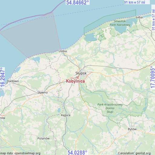
Kobylnica GPS coordinates[2]
54° 26' 23.1" North, 16° 59' 52.152" East
| Map corner | latitude | longitude |
|---|---|---|
| Upper-left | 54.84662°, | 16.2947° |
| Center: | 54.43975°, | 16.99782° |
| Lower-right: | 54.0288°, | 17.70095° |
| Map W x H: | 90.9×90.9 km | = 56.5×56.5mi |
| max Lat: | 54.83135° ⇑1.5% North |
| Kobylnica: | 54.43975° |
| min Lat: | ⇓98.5% South 49.21328° |
| min Long | Kobylnica | max Long |
| 14.20249° | 16.99782° | 24.03723° |
| W 15.2%⇐ | ⇒84.8% E |
Elevation
Elevation of Kobylnica is 29 m = 95 ft, and this is 162.4 m = 533 ft below average elevation for this country.
| Max E: |
974 m = 3196 ft | 96.3% |
| Avg. | 191.4 m = 628 ft | |
| Kobylnica | 29 m = 95 ft | |
Min E: |
-3 m = -10 ft | 3.7% |
See also: Poland elevation on elevation.city.
Geographical zone
Kobylnica is located in North temperate zone (between Tropic of Cancer and the Arctic Circle). Distance of this North polar circle is 1348 km =837.6 mi to North.| Distance of | km | miles | from Kobylnica |
|---|---|---|---|
| North Pole | 3953.9 | 2456.8 | to North |
| Arctic Circle | 1348 | 837.6 | to North |
| Tropic Cancer | 3447.2 | 2142 | to South |
| Equator | 6053.1 | 3761.2 | to South |


Nearby cities:
15 places around Kobylnica: (largest is in red/bold)
• Barcino
18.2 km =11.3 mi,  187°
187°
• Bobrowniki
23.9 km =14.9 mi,  66°
66°
• Damnica
18.9 km =11.7 mi, 69°
• Dębnica Kaszubska
12.6 km =7.8 mi,  122°
122°
• Kołczygłowy
27 km =16.8 mi,  145°
145°
• Kępice
23.2 km =14.4 mi,  197°
197°
• Objazda
18.9 km =11.7 mi,  9°
9°
• Ostrowiec
28 km =17.4 mi,  229°
229°
• Postomino
19.3 km =12 mi,  288°
288°
• Smołdzino
28.5 km =17.7 mi,  29°
29°
• Sławno
22.3 km =13.9 mi,  247°
247°
• Słupsk
3.4 km =2.1 mi,  36°
36°
• Trzebielino
27.3 km =17 mi,  167°
167°
• Ustka
17.9 km =11.1 mi,  330°
330°
• Łupawa
27.1 km =16.8 mi,  94°
94°
Sources, notices
• [Note1] Compared only with cities in Poland existing in our database
• [Src1] Map data: © OpenStreetMap contributors (CC-BY-SA)
• [Src2] Other city data from geonames.org with taken over terms of usage.
• [Src3] Geographical zone / Annual Mean Temperature by Robert A. Rohde @ Wikipedia
