Lipinki geodata
Lipinki (Warmia-Masuria) is a populated place; located in Poland in Europe/Warsaw (GMT+2) time zone. With population of 760 people, there are 2931 cities with bigger population in this country. Compared to other cities in Poland, 89.3% of cities are located further ↓South; 54.1% of cities are located further →East and 83.2% of cities have higher elevation than Lipinki. Note1


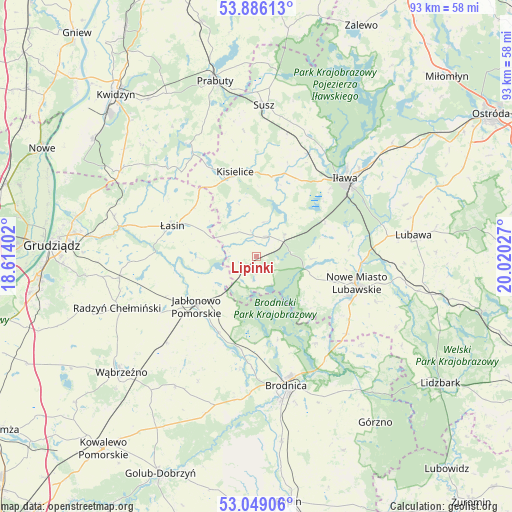
Lipinki GPS coordinates[2]
53° 28' 10.776" North, 19° 19' 1.704" East
| Map corner | latitude | longitude |
|---|---|---|
| Upper-left | 53.88613°, | 18.61402° |
| Center: | 53.46966°, | 19.31714° |
| Lower-right: | 53.04906°, | 20.02027° |
| Map W x H: | 93.1×93.1 km | = 57.8×57.8mi |
| max Lat: | 54.83135° ⇑10.7% North |
| Lipinki: | 53.46966° |
| min Lat: | ⇓89.3% South 49.21328° |
| min Long | Lipinki | max Long |
| 14.20249° | 19.31714° | 24.03723° |
| W 45.9%⇐ | ⇒54.1% E |
Elevation
Elevation of Lipinki is 93 m = 305 ft, and this is 98.4 m = 323 ft below average elevation for this country.
| Max E: |
974 m = 3196 ft | 83.2% |
| Avg. | 191.4 m = 628 ft | |
| Lipinki | 93 m = 305 ft | |
Min E: |
-3 m = -10 ft | 16.8% |
See also: Poland elevation on elevation.city.
Geographical zone
Lipinki is located in North temperate zone (between Tropic of Cancer and the Arctic Circle). Distance of this North polar circle is 1455.9 km =904.7 mi to North.| Distance of | km | miles | from Lipinki |
|---|---|---|---|
| North Pole | 4061.8 | 2523.9 | to North |
| Arctic Circle | 1455.9 | 904.7 | to North |
| Tropic Cancer | 3339.3 | 2074.9 | to South |
| Equator | 5945.3 | 3694.2 | to South |


Nearby cities:
15 places around Lipinki: (largest is in red/bold)
• Biskupiec
4.1 km =2.5 mi,  32°
32°
• Bobrowo
20.7 km =12.9 mi,  188°
188°
• Brodnica
23.9 km =14.9 mi,  167°
167°
• Brzozie Lubawskie
21.6 km =13.4 mi,  130°
130°
• Gruta
23.9 km =14.9 mi,  265°
265°
• Iława
21.8 km =13.5 mi,  49°
49°
• Jabłonowo Pomorskie
13.8 km =8.6 mi,  230°
230°
• Kisielice
15.8 km =9.8 mi,  347°
347°
• Książki
22.6 km =14 mi, 226°
• Kurzętnik
19 km =11.8 mi,  114°
114°
• Nowe Miasto Lubawskie
19.2 km =11.9 mi, 106°
• Ostrowite
6.3 km =3.9 mi,  207°
207°
• Zbiczno
15.6 km =9.7 mi, 165°
• Łasin
16.1 km =10 mi,  289°
289°
• Świecie nad Osą
14.5 km =9 mi,  258°
258°
Sources, notices
• [Note1] Compared only with cities in Poland existing in our database
• [Src1] Map data: © OpenStreetMap contributors (CC-BY-SA)
• [Src2] Other city data from geonames.org with taken over terms of usage.
• [Src3] Geographical zone / Annual Mean Temperature by Robert A. Rohde @ Wikipedia
