Łasin geodata
Łasin (Kujawsko-Pomorskie) is a seat of a third-order administrative division; located in Poland in Europe/Warsaw (GMT+2) time zone. With population of 3,285 people, there are 972 cities with bigger population in this country. Compared to other cities in Poland, 89.8% of cities are located further ↓South; 58.6% of cities are located further →East and 83.7% of cities have higher elevation than Łasin. Note1


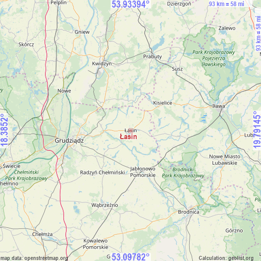
Łasin GPS coordinates[2]
53° 31' 4.584" North, 19° 5' 17.952" East
| Map corner | latitude | longitude |
|---|---|---|
| Upper-left | 53.93394°, | 18.3852° |
| Center: | 53.51794°, | 19.08832° |
| Lower-right: | 53.09782°, | 19.79145° |
| Map W x H: | 93×93 km | = 57.8×57.8mi |
| max Lat: | 54.83135° ⇑10.2% North |
| Łasin: | 53.51794° |
| min Lat: | ⇓89.8% South 49.21328° |
| min Long | Łasin | max Long |
| 14.20249° | 19.08832° | 24.03723° |
| W 41.4%⇐ | ⇒58.6% E |
Elevation
Elevation of Łasin is 92 m = 302 ft, and this is 99.4 m = 326 ft below average elevation for this country.
| Max E: |
974 m = 3196 ft | 83.7% |
| Avg. | 191.4 m = 628 ft | |
| Łasin | 92 m = 302 ft | |
Min E: |
-3 m = -10 ft | 16.3% |
See also: Poland elevation on elevation.city.
Geographical zone
Łasin is located in North temperate zone (between Tropic of Cancer and the Arctic Circle). Distance of this North polar circle is 1450.5 km =901.3 mi to North.| Distance of | km | miles | from Łasin |
|---|---|---|---|
| North Pole | 4056.4 | 2520.5 | to North |
| Arctic Circle | 1450.5 | 901.3 | to North |
| Tropic Cancer | 3344.7 | 2078.3 | to South |
| Equator | 5950.6 | 3697.5 | to South |


Nearby cities:
15 places around Łasin: (largest is in red/bold)
• Biskupiec
17.4 km =10.8 mi,  96°
96°
• Dragasz
23.1 km =14.4 mi,  266°
266°
• Gardeja
14 km =8.7 mi,  318°
318°
• Grudziądz
22.5 km =14 mi,  260°
260°
• Gruta
11.3 km =7 mi,  230°
230°
• Jabłonowo Pomorskie
14.8 km =9.2 mi,  162°
162°
• Kisielice
15.3 km =9.5 mi,  48°
48°
• Książki
21 km =13 mi,  183°
183°
• Kwidzyn
25.2 km =15.7 mi,  335°
335°
• Lipinki
16.1 km =10 mi,  109°
109°
• Ostrowite
16.4 km =10.2 mi,  131°
131°
• Radzyń Chełmiński
17.8 km =11.1 mi,  214°
214°
• Rogóźno
10.7 km =6.6 mi,  280°
280°
• Sadlinki
21.9 km =13.6 mi, 318°
• Świecie nad Osą
8.3 km =5.2 mi,  173°
173°
Sources, notices
• [Note1] Compared only with cities in Poland existing in our database
• [Src1] Map data: © OpenStreetMap contributors (CC-BY-SA)
• [Src2] Other city data from geonames.org with taken over terms of usage.
• [Src3] Geographical zone / Annual Mean Temperature by Robert A. Rohde @ Wikipedia
