Gruta geodata
Gruta (Kujawsko-Pomorskie) is a seat of a third-order administrative division; located in Poland in Europe/Warsaw (GMT+2) time zone. With population of 1,600 people, there are 1751 cities with bigger population in this country. Compared to other cities in Poland, 89.1% of cities are located further ↓South; 60.7% of cities are located further →East and 83.2% of cities have higher elevation than Gruta. Note1


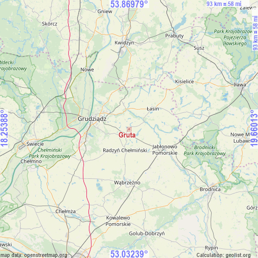
Gruta GPS coordinates[2]
53° 27' 11.34" North, 18° 57' 25.2" East
| Map corner | latitude | longitude |
|---|---|---|
| Upper-left | 53.86979°, | 18.25388° |
| Center: | 53.45315°, | 18.957° |
| Lower-right: | 53.03239°, | 19.66013° |
| Map W x H: | 93.1×93.1 km | = 57.8×57.8mi |
| max Lat: | 54.83135° ⇑10.9% North |
| Gruta: | 53.45315° |
| min Lat: | ⇓89.1% South 49.21328° |
| min Long | Gruta | max Long |
| 14.20249° | 18.957° | 24.03723° |
| W 39.3%⇐ | ⇒60.7% E |
Elevation
Elevation of Gruta is 93 m = 305 ft, and this is 98.4 m = 323 ft below average elevation for this country.
| Max E: |
974 m = 3196 ft | 83.2% |
| Avg. | 191.4 m = 628 ft | |
| Gruta | 93 m = 305 ft | |
Min E: |
-3 m = -10 ft | 16.8% |
See also: Poland elevation on elevation.city.
Geographical zone
Gruta is located in North temperate zone (between Tropic of Cancer and the Arctic Circle). Distance of this North polar circle is 1457.7 km =905.8 mi to North.| Distance of | km | miles | from Gruta |
|---|---|---|---|
| North Pole | 4063.6 | 2525 | to North |
| Arctic Circle | 1457.7 | 905.8 | to North |
| Tropic Cancer | 3337.5 | 2073.8 | to South |
| Equator | 5943.4 | 3693.1 | to South |


Nearby cities:
15 places around Gruta: (largest is in red/bold)
• Dragasz
15.6 km =9.7 mi,  292°
292°
• Dębowa Łąka
23.8 km =14.8 mi,  157°
157°
• Gardeja
17.6 km =10.9 mi,  357°
357°
• Grudziądz
13.9 km =8.6 mi,  284°
284°
• Jabłonowo Pomorskie
14.8 km =9.2 mi,  117°
117°
• Książki
15.6 km =9.7 mi,  151°
151°
• Lipinki
23.9 km =14.9 mi,  85°
85°
• Ostrowite
21.3 km =13.2 mi,  100°
100°
• Płużnica
21.1 km =13.1 mi,  214°
214°
• Radzyń Chełmiński
7.7 km =4.8 mi,  189°
189°
• Rogóźno
9.4 km =5.8 mi,  348°
348°
• Sadlinki
24.3 km =15.1 mi, 346°
• Wąbrzeźno
19.3 km =12 mi,  181°
181°
• Łasin
11.3 km =7 mi,  50°
50°
• Świecie nad Osą
9.6 km =6 mi, 96°
Sources, notices
• [Note1] Compared only with cities in Poland existing in our database
• [Src1] Map data: © OpenStreetMap contributors (CC-BY-SA)
• [Src2] Other city data from geonames.org with taken over terms of usage.
• [Src3] Geographical zone / Annual Mean Temperature by Robert A. Rohde @ Wikipedia
