Iława geodata
Iława (Warmia-Masuria) is a populated place; located in Poland in Europe/Warsaw (GMT+2) time zone. With population of 32,557 people, there are 157 cities with bigger population in this country. Compared to other cities in Poland, 90.6% of cities are located further ↓South; 50.1% of cities are located further ←West and 77.2% of cities have higher elevation than Iława. Note1


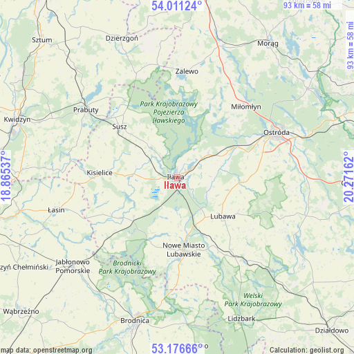
Iława GPS coordinates[2]
53° 35' 45.636" North, 19° 34' 6.564" East
| Map corner | latitude | longitude |
|---|---|---|
| Upper-left | 54.01124°, | 18.86537° |
| Center: | 53.59601°, | 19.56849° |
| Lower-right: | 53.17666°, | 20.27162° |
| Map W x H: | 92.8×92.8 km | = 57.7×57.7mi |
| max Lat: | 54.83135° ⇑9.4% North |
| Iława: | 53.59601° |
| min Lat: | ⇓90.6% South 49.21328° |
| min Long | Iława | max Long |
| 14.20249° | 19.56849° | 24.03723° |
| W 50.1%⇐ | ⇒49.9% E |
Elevation
Elevation of Iława is 105 m = 344 ft, and this is 86.4 m = 283 ft below average elevation for this country.
| Max E: |
974 m = 3196 ft | 77.2% |
| Avg. | 191.4 m = 628 ft | |
| Iława | 105 m = 344 ft | |
Min E: |
-3 m = -10 ft | 22.8% |
See also: Poland elevation on elevation.city.
Geographical zone
Iława is located in North temperate zone (between Tropic of Cancer and the Arctic Circle). Distance of this North polar circle is 1441.9 km =896 mi to North.| Distance of | km | miles | from Iława |
|---|---|---|---|
| North Pole | 4047.7 | 2515.1 | to North |
| Arctic Circle | 1441.9 | 896 | to North |
| Tropic Cancer | 3353.4 | 2083.7 | to South |
| Equator | 5959.3 | 3702.9 | to South |


Nearby cities:
15 places around Iława: (largest is in red/bold)
• Biskupiec
17.9 km =11.1 mi,  233°
233°
• Brzozie Lubawskie
28.1 km =17.5 mi,  180°
180°
• Grabowo
17 km =10.6 mi,  102°
102°
• Grodziczno
24 km =14.9 mi,  147°
147°
• Kisielice
20.2 km =12.6 mi,  273°
273°
• Kurzętnik
22 km =13.7 mi, 178°
• Lipinki
21.8 km =13.5 mi, 229°
• Lubawa
15.7 km =9.8 mi,  130°
130°
• Miłomłyn
25.8 km =16 mi,  43°
43°
• Nowe Miasto Lubawskie
19.6 km =12.2 mi,  174°
174°
• Ostrowite
27.6 km =17.1 mi,  224°
224°
• Ostróda
28.4 km =17.6 mi,  66°
66°
• Prabuty
29.7 km =18.5 mi,  306°
306°
• Susz
20.4 km =12.7 mi, 311°
• Zalewo
27.8 km =17.3 mi,  4°
4°
Sources, notices
• [Note1] Compared only with cities in Poland existing in our database
• [Src1] Map data: © OpenStreetMap contributors (CC-BY-SA)
• [Src2] Other city data from geonames.org with taken over terms of usage.
• [Src3] Geographical zone / Annual Mean Temperature by Robert A. Rohde @ Wikipedia
