Zalas geodata
Zalas (Lesser Poland) is a populated place; located in Poland in Europe/Warsaw (GMT+2) time zone. With population of 2,240 people, there are 1339 cities with bigger population in this country. Compared to other cities in Poland, 78.9% of cities are located further ↑North; 51.2% of cities are located further ←West and 91.6% of cities have lower elevation than Zalas. Note1


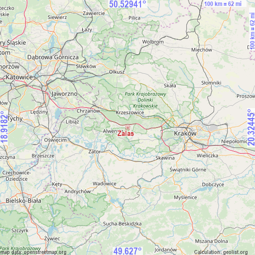
Zalas GPS coordinates[2]
50° 4' 49.188" North, 19° 37' 16.752" East
| Map corner | latitude | longitude |
|---|---|---|
| Upper-left | 50.52941°, | 18.9182° |
| Center: | 50.08033°, | 19.62132° |
| Lower-right: | 49.627°, | 20.32445° |
| Map W x H: | 100.3×100.3 km | = 62.3×62.3mi |
| max Lat: | 54.83135° ⇑78.9% North |
| Zalas: | 50.08033° |
| min Lat: | ⇓21.1% South 49.21328° |
| min Long | Zalas | max Long |
| 14.20249° | 19.62132° | 24.03723° |
| W 51.2%⇐ | ⇒48.8% E |
Elevation
Elevation of Zalas is 351 m = 1152 ft, and this is 159.6 m = 524 ft above average elevation for this country.
| Max E: |
974 m = 3196 ft | 8.4% |
| Zalas | 351 m 1152 ft | |
| Avg. | 191.4 m = 628 ft | |
Min E: |
-3 m = -10 ft | 91.6% |
See also: Poland elevation on elevation.city.
Geographical zone
Zalas is located in North temperate zone (between Tropic of Cancer and the Arctic Circle). Distance of this North polar circle is 1832.8 km =1138.8 mi to North.| Distance of | km | miles | from Zalas |
|---|---|---|---|
| North Pole | 4438.7 | 2758.1 | to North |
| Arctic Circle | 1832.8 | 1138.8 | to North |
| Tropic Cancer | 2962.5 | 1840.8 | to South |
| Equator | 5568.4 | 3460 | to South |


Nearby cities:
15 places around Zalas: (largest is in red/bold)
• Alwernia
6.2 km =3.9 mi,  249°
249°
• Brodła
4.7 km =2.9 mi,  209°
209°
• Brzoskwinia
6.7 km =4.2 mi,  76°
76°
• Czułów
6.1 km =3.8 mi,  112°
112°
• Grojec
4.7 km =2.9 mi,  282°
282°
• Krzeszowice
7 km =4.3 mi,  6°
6°
• Mników
7.8 km =4.8 mi, 106°
• Nielepice
6.5 km =4 mi,  61°
61°
• Przeginia Duchowna
7 km =4.3 mi,  160°
160°
• Regulice
6.7 km =4.2 mi,  272°
272°
• Rudawa
7.9 km =4.9 mi,  54°
54°
• Rudno
3.8 km =2.4 mi,  303°
303°
• Sanka
2.2 km =1.4 mi,  126°
126°
• Tenczynek
4.4 km =2.7 mi,  352°
352°
• Wola Filipowska
6.7 km =4.2 mi,  333°
333°
Sources, notices
• [Note1] Compared only with cities in Poland existing in our database
• [Src1] Map data: © OpenStreetMap contributors (CC-BY-SA)
• [Src2] Other city data from geonames.org with taken over terms of usage.
• [Src3] Geographical zone / Annual Mean Temperature by Robert A. Rohde @ Wikipedia
