Grojec geodata
Grojec (Lesser Poland) is a populated place; located in Poland in Europe/Warsaw (GMT+2) time zone. With population of 1,259 people, there are 2117 cities with bigger population in this country. Compared to other cities in Poland, 78.5% of cities are located further ↑North; 50.1% of cities are located further →East and 92.4% of cities have lower elevation than Grojec. Note1


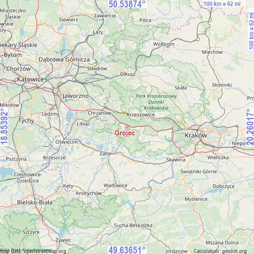
Grojec GPS coordinates[2]
50° 5' 23.1" North, 19° 33' 25.344" East
| Map corner | latitude | longitude |
|---|---|---|
| Upper-left | 50.53874°, | 18.85392° |
| Center: | 50.08975°, | 19.55704° |
| Lower-right: | 49.63651°, | 20.26017° |
| Map W x H: | 100.3×100.3 km | = 62.3×62.3mi |
| max Lat: | 54.83135° ⇑78.5% North |
| Grojec: | 50.08975° |
| min Lat: | ⇓21.5% South 49.21328° |
| min Long | Grojec | max Long |
| 14.20249° | 19.55704° | 24.03723° |
| W 49.9%⇐ | ⇒50.1% E |
Elevation
Elevation of Grojec is 361 m = 1184 ft, and this is 169.6 m = 556 ft above average elevation for this country.
| Max E: |
974 m = 3196 ft | 7.6% |
| Grojec | 361 m 1184 ft | |
| Avg. | 191.4 m = 628 ft | |
Min E: |
-3 m = -10 ft | 92.4% |
See also: Poland elevation on elevation.city.
Geographical zone
Grojec is located in North temperate zone (between Tropic of Cancer and the Arctic Circle). Distance of this North polar circle is 1831.7 km =1138.2 mi to North.| Distance of | km | miles | from Grojec |
|---|---|---|---|
| North Pole | 4437.6 | 2757.4 | to North |
| Arctic Circle | 1831.7 | 1138.2 | to North |
| Tropic Cancer | 2963.5 | 1841.4 | to South |
| Equator | 5569.5 | 3460.7 | to South |


Nearby cities:
15 places around Grojec: (largest is in red/bold)
• Alwernia
3.5 km =2.2 mi,  201°
201°
• Bolęcin
6.2 km =3.9 mi,  299°
299°
• Brodła
5.6 km =3.5 mi,  156°
156°
• Filipowice
7.4 km =4.6 mi,  4°
4°
• Krzeszowice
7.9 km =4.9 mi,  42°
42°
• Kwaczała
5.4 km =3.4 mi,  238°
238°
• Okleśna
6.8 km =4.2 mi, 195°
• Płaza
6.7 km =4.2 mi,  279°
279°
• Regulice
2.2 km =1.4 mi,  250°
250°
• Rozkochów
6.9 km =4.3 mi,  223°
223°
• Rudno
1.8 km =1.1 mi,  53°
53°
• Sanka
6.8 km =4.2 mi,  110°
110°
• Tenczynek
5.2 km =3.2 mi, 50°
• Wola Filipowska
5.2 km =3.2 mi,  18°
18°
• Zalas
4.7 km =2.9 mi,  102°
102°
Sources, notices
• [Note1] Compared only with cities in Poland existing in our database
• [Src1] Map data: © OpenStreetMap contributors (CC-BY-SA)
• [Src2] Other city data from geonames.org with taken over terms of usage.
• [Src3] Geographical zone / Annual Mean Temperature by Robert A. Rohde @ Wikipedia
