Rudno geodata
Rudno (Lesser Poland) is a populated place; located in Poland in Europe/Warsaw (GMT+2) time zone. With population of 745 people, there are 2987 cities with bigger population in this country. Compared to other cities in Poland, 78% of cities are located further ↑North; 50.3% of cities are located further ←West and 90.4% of cities have lower elevation than Rudno. Note1


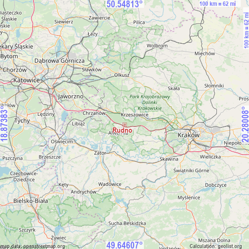
Rudno GPS coordinates[2]
50° 5' 57.192" North, 19° 34' 37.02" East
| Map corner | latitude | longitude |
|---|---|---|
| Upper-left | 50.54813°, | 18.87383° |
| Center: | 50.09922°, | 19.57695° |
| Lower-right: | 49.64607°, | 20.28008° |
| Map W x H: | 100.3×100.3 km | = 62.3×62.3mi |
| max Lat: | 54.83135° ⇑78% North |
| Rudno: | 50.09922° |
| min Lat: | ⇓22% South 49.21328° |
| min Long | Rudno | max Long |
| 14.20249° | 19.57695° | 24.03723° |
| W 50.3%⇐ | ⇒49.7% E |
Elevation
Elevation of Rudno is 336 m = 1102 ft, and this is 144.6 m = 474 ft above average elevation for this country.
| Max E: |
974 m = 3196 ft | 9.6% |
| Rudno | 336 m 1102 ft | |
| Avg. | 191.4 m = 628 ft | |
Min E: |
-3 m = -10 ft | 90.4% |
See also: Poland elevation on elevation.city.
Geographical zone
Rudno is located in North temperate zone (between Tropic of Cancer and the Arctic Circle). Distance of this North polar circle is 1830.7 km =1137.5 mi to North.| Distance of | km | miles | from Rudno |
|---|---|---|---|
| North Pole | 4436.6 | 2756.8 | to North |
| Arctic Circle | 1830.7 | 1137.5 | to North |
| Tropic Cancer | 2964.6 | 1842.1 | to South |
| Equator | 5570.5 | 3461.3 | to South |


Nearby cities:
15 places around Rudno: (largest is in red/bold)
• Alwernia
5.1 km =3.2 mi,  211°
211°
• Bolęcin
7.1 km =4.4 mi,  286°
286°
• Brodła
6.3 km =3.9 mi,  172°
172°
• Filipowice
6.3 km =3.9 mi,  352°
352°
• Grojec
1.8 km =1.1 mi,  233°
233°
• Krzeszowice
6.2 km =3.9 mi,  39°
39°
• Kwaczała
7.2 km =4.5 mi,  237°
237°
• Miękinia
6.7 km =4.2 mi,  19°
19°
• Nowa Góra
8.3 km =5.2 mi,  7°
7°
• Płaza
8 km =5 mi,  270°
270°
• Regulice
3.9 km =2.4 mi, 242°
• Sanka
6 km =3.7 mi,  124°
124°
• Tenczynek
3.5 km =2.2 mi,  48°
48°
• Wola Filipowska
3.9 km =2.4 mi,  3°
3°
• Zalas
3.8 km =2.4 mi, 123°
Sources, notices
• [Note1] Compared only with cities in Poland existing in our database
• [Src1] Map data: © OpenStreetMap contributors (CC-BY-SA)
• [Src2] Other city data from geonames.org with taken over terms of usage.
• [Src3] Geographical zone / Annual Mean Temperature by Robert A. Rohde @ Wikipedia
