Kruszyna geodata
Kruszyna (Silesia) is a populated place; located in Poland in Europe/Warsaw (GMT+2) time zone. With population of 968 people, there are 2559 cities with bigger population in this country. Compared to other cities in Poland, 56% of cities are located further ↑North; 54.7% of cities are located further →East and 71.6% of cities have lower elevation than Kruszyna. Note1


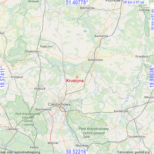
Kruszyna GPS coordinates[2]
50° 58' 1.488" North, 19° 16' 38.028" East
| Map corner | latitude | longitude |
|---|---|---|
| Upper-left | 51.40778°, | 18.57411° |
| Center: | 50.96708°, | 19.27723° |
| Lower-right: | 50.52216°, | 19.98036° |
| Map W x H: | 98.5×98.5 km | = 61.2×61.2mi |
| max Lat: | 54.83135° ⇑56% North |
| Kruszyna: | 50.96708° |
| min Lat: | ⇓44% South 49.21328° |
| min Long | Kruszyna | max Long |
| 14.20249° | 19.27723° | 24.03723° |
| W 45.3%⇐ | ⇒54.7% E |
Elevation
Elevation of Kruszyna is 234 m = 768 ft, and this is 42.6 m = 140 ft above average elevation for this country.
| Max E: |
974 m = 3196 ft | 28.4% |
| Kruszyna | 234 m 768 ft | |
| Avg. | 191.4 m = 628 ft | |
Min E: |
-3 m = -10 ft | 71.6% |
See also: Poland elevation on elevation.city.
Geographical zone
Kruszyna is located in North temperate zone (between Tropic of Cancer and the Arctic Circle). Distance of this North polar circle is 1734.2 km =1077.6 mi to North.| Distance of | km | miles | from Kruszyna |
|---|---|---|---|
| North Pole | 4340.1 | 2696.8 | to North |
| Arctic Circle | 1734.2 | 1077.6 | to North |
| Tropic Cancer | 3061.1 | 1902.1 | to South |
| Equator | 5667 | 3521.3 | to South |


Nearby cities:
15 places around Kruszyna: (largest is in red/bold)
• Biała Dolna
18.9 km =11.7 mi,  233°
233°
• Bogusławice
1.8 km =1.1 mi, 225°
• Borowno
3.9 km =2.4 mi,  183°
183°
• Gidle
13.6 km =8.5 mi,  92°
92°
• Kościelec
8.9 km =5.5 mi,  209°
209°
• Kłomnice
7.5 km =4.7 mi,  132°
132°
• Mstów
15.3 km =9.5 mi, 177°
• Mykanów
7.2 km =4.5 mi, 228°
• Nowa Brzeźnica
14.3 km =8.9 mi,  332°
332°
• Ostrowy nad Okszą
15.7 km =9.8 mi,  274°
274°
• Pławno
12.5 km =7.8 mi,  84°
84°
• Radomsko
16.2 km =10.1 mi,  46°
46°
• Radziechowice Pierwsze
11.8 km =7.3 mi,  16°
16°
• Rudniki
10.1 km =6.3 mi,  192°
192°
• Rędziny
12.7 km =7.9 mi,  199°
199°
Sources, notices
• [Note1] Compared only with cities in Poland existing in our database
• [Src1] Map data: © OpenStreetMap contributors (CC-BY-SA)
• [Src2] Other city data from geonames.org with taken over terms of usage.
• [Src3] Geographical zone / Annual Mean Temperature by Robert A. Rohde @ Wikipedia
