Biała Dolna geodata
Biała Dolna (Silesia) is a populated place; located in Poland in Europe/Warsaw (GMT+2) time zone. With population of 823 people, there are 2814 cities with bigger population in this country. Compared to other cities in Poland, 58.7% of cities are located further ↑North; 58.9% of cities are located further →East and 71.9% of cities have lower elevation than Biała Dolna. Note1


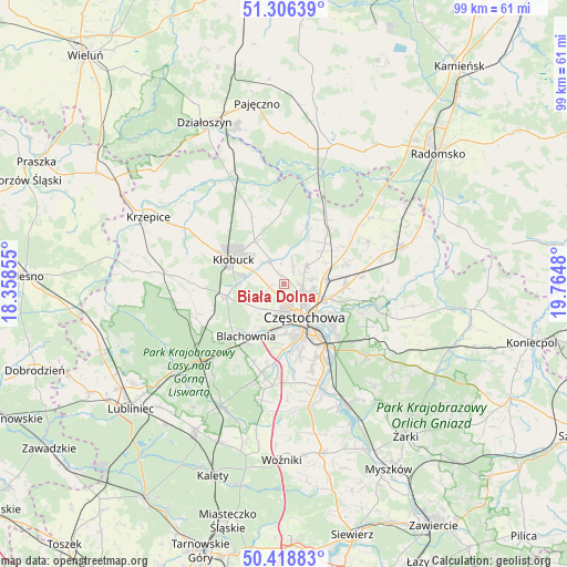
Biała Dolna GPS coordinates[2]
50° 51' 52.992" North, 19° 3' 42.012" East
| Map corner | latitude | longitude |
|---|---|---|
| Upper-left | 51.30639°, | 18.35855° |
| Center: | 50.86472°, | 19.06167° |
| Lower-right: | 50.41883°, | 19.7648° |
| Map W x H: | 98.7×98.7 km | = 61.3×61.3mi |
| max Lat: | 54.83135° ⇑58.7% North |
| Biała Dolna: | 50.86472° |
| min Lat: | ⇓41.3% South 49.21328° |
| min Long | Biała Dolna | max Long |
| 14.20249° | 19.06167° | 24.03723° |
| W 41.1%⇐ | ⇒58.9% E |
Elevation
Elevation of Biała Dolna is 235 m = 771 ft, and this is 43.6 m = 143 ft above average elevation for this country.
| Max E: |
974 m = 3196 ft | 28.1% |
| Biała Dolna | 235 m 771 ft | |
| Avg. | 191.4 m = 628 ft | |
Min E: |
-3 m = -10 ft | 71.9% |
See also: Poland elevation on elevation.city.
Geographical zone
Biała Dolna is located in North temperate zone (between Tropic of Cancer and the Arctic Circle). Distance of this North polar circle is 1745.5 km =1084.6 mi to North.| Distance of | km | miles | from Biała Dolna |
|---|---|---|---|
| North Pole | 4351.4 | 2703.8 | to North |
| Arctic Circle | 1745.5 | 1084.6 | to North |
| Tropic Cancer | 3049.7 | 1895 | to South |
| Equator | 5655.6 | 3514.2 | to South |


Nearby cities:
15 places around Biała Dolna: (largest is in red/bold)
• Blachownia
11.6 km =7.2 mi,  216°
216°
• Częstochowa
8.8 km =5.5 mi,  149°
149°
• Huta Stara B
15 km =9.3 mi,  160°
160°
• Kalej
6.3 km =3.9 mi,  240°
240°
• Kamyk
4.7 km =2.9 mi,  330°
330°
• Konopiska
15.8 km =9.8 mi,  193°
193°
• Kościelec
11.4 km =7.1 mi,  71°
71°
• Kłobuck
9.6 km =6 mi,  294°
294°
• Miedzno
13 km =8.1 mi, 334°
• Mykanów
11.7 km =7.3 mi,  56°
56°
• Ostrowy nad Okszą
12.6 km =7.8 mi,  357°
357°
• Rudniki
13 km =8.1 mi,  83°
83°
• Rędziny
10.9 km =6.8 mi,  93°
93°
• Wręczyca Wielka
10.1 km =6.3 mi,  258°
258°
• Łobodno
8.9 km =5.5 mi, 325°
Sources, notices
• [Note1] Compared only with cities in Poland existing in our database
• [Src1] Map data: © OpenStreetMap contributors (CC-BY-SA)
• [Src2] Other city data from geonames.org with taken over terms of usage.
• [Src3] Geographical zone / Annual Mean Temperature by Robert A. Rohde @ Wikipedia
