Kłomnice geodata
Kłomnice (Silesia) is a seat of a third-order administrative division; located in Poland in Europe/Warsaw (GMT+2) time zone. With population of 2,802 people, there are 1118 cities with bigger population in this country. Compared to other cities in Poland, 57.1% of cities are located further ↑North; 53.4% of cities are located further →East and 70.4% of cities have lower elevation than Kłomnice. Note1


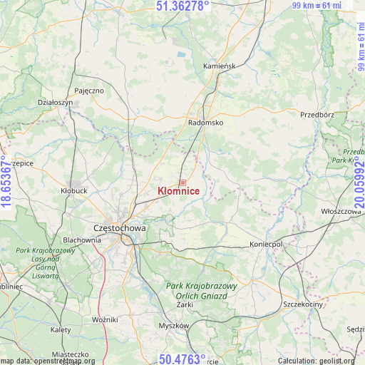
Kłomnice GPS coordinates[2]
50° 55' 17.94" North, 19° 21' 24.444" East
| Map corner | latitude | longitude |
|---|---|---|
| Upper-left | 51.36278°, | 18.65367° |
| Center: | 50.92165°, | 19.35679° |
| Lower-right: | 50.4763°, | 20.05992° |
| Map W x H: | 98.6×98.6 km | = 61.3×61.3mi |
| max Lat: | 54.83135° ⇑57.1% North |
| Kłomnice: | 50.92165° |
| min Lat: | ⇓42.9% South 49.21328° |
| min Long | Kłomnice | max Long |
| 14.20249° | 19.35679° | 24.03723° |
| W 46.6%⇐ | ⇒53.4% E |
Elevation
Elevation of Kłomnice is 230 m = 755 ft, and this is 38.6 m = 127 ft above average elevation for this country.
| Max E: |
974 m = 3196 ft | 29.6% |
| Kłomnice | 230 m 755 ft | |
| Avg. | 191.4 m = 628 ft | |
Min E: |
-3 m = -10 ft | 70.4% |
See also: Poland elevation on elevation.city.
Geographical zone
Kłomnice is located in North temperate zone (between Tropic of Cancer and the Arctic Circle). Distance of this North polar circle is 1739.2 km =1080.7 mi to North.| Distance of | km | miles | from Kłomnice |
|---|---|---|---|
| North Pole | 4345.1 | 2699.9 | to North |
| Arctic Circle | 1739.2 | 1080.7 | to North |
| Tropic Cancer | 3056 | 1898.9 | to South |
| Equator | 5662 | 3518.2 | to South |


Nearby cities:
15 places around Kłomnice: (largest is in red/bold)
• Bogusławice
7.8 km =4.8 mi,  299°
299°
• Borowno
5.9 km =3.7 mi,  281°
281°
• Dąbrowa Zielona
16.5 km =10.3 mi,  121°
121°
• Gidle
9.2 km =5.7 mi,  60°
60°
• Kościelec
10.3 km =6.4 mi,  254°
254°
• Kruszyna
7.5 km =4.7 mi,  312°
312°
• Mstów
11.4 km =7.1 mi,  206°
206°
• Mykanów
11 km =6.8 mi,  271°
271°
• Przyrów
18 km =11.2 mi,  138°
138°
• Pławno
9.3 km =5.8 mi,  47°
47°
• Radomsko
17.3 km =10.7 mi,  20°
20°
• Radziechowice Pierwsze
16.5 km =10.3 mi,  352°
352°
• Rudniki
9.1 km =5.7 mi,  238°
238°
• Rędziny
12.1 km =7.5 mi,  234°
234°
• Żytno
19 km =11.8 mi,  88°
88°
Sources, notices
• [Note1] Compared only with cities in Poland existing in our database
• [Src1] Map data: © OpenStreetMap contributors (CC-BY-SA)
• [Src2] Other city data from geonames.org with taken over terms of usage.
• [Src3] Geographical zone / Annual Mean Temperature by Robert A. Rohde @ Wikipedia
