Kościelec geodata
Kościelec (Silesia) is a populated place; located in Poland in Europe/Warsaw (GMT+2) time zone. With population of 1,706 people, there are 1673 cities with bigger population in this country. Compared to other cities in Poland, 57.9% of cities are located further ↑North; 55.7% of cities are located further →East and 72.4% of cities have lower elevation than Kościelec. Note1


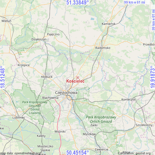
Kościelec GPS coordinates[2]
50° 53' 49.668" North, 19° 12' 56.16" East
| Map corner | latitude | longitude |
|---|---|---|
| Upper-left | 51.33849°, | 18.51248° |
| Center: | 50.89713°, | 19.2156° |
| Lower-right: | 50.45154°, | 19.91873° |
| Map W x H: | 98.6×98.6 km | = 61.3×61.3mi |
| max Lat: | 54.83135° ⇑57.9% North |
| Kościelec: | 50.89713° |
| min Lat: | ⇓42.1% South 49.21328° |
| min Long | Kościelec | max Long |
| 14.20249° | 19.2156° | 24.03723° |
| W 44.3%⇐ | ⇒55.7% E |
Elevation
Elevation of Kościelec is 237 m = 778 ft, and this is 45.6 m = 150 ft above average elevation for this country.
| Max E: |
974 m = 3196 ft | 27.6% |
| Kościelec | 237 m 778 ft | |
| Avg. | 191.4 m = 628 ft | |
Min E: |
-3 m = -10 ft | 72.4% |
See also: Poland elevation on elevation.city.
Geographical zone
Kościelec is located in North temperate zone (between Tropic of Cancer and the Arctic Circle). Distance of this North polar circle is 1741.9 km =1082.4 mi to North.| Distance of | km | miles | from Kościelec |
|---|---|---|---|
| North Pole | 4347.8 | 2701.6 | to North |
| Arctic Circle | 1741.9 | 1082.4 | to North |
| Tropic Cancer | 3053.3 | 1897.2 | to South |
| Equator | 5659.2 | 3516.5 | to South |


Nearby cities:
15 places around Kościelec: (largest is in red/bold)
• Biała Dolna
11.4 km =7.1 mi,  251°
251°
• Bogusławice
7.2 km =4.5 mi,  25°
25°
• Borowno
5.7 km =3.5 mi,  46°
46°
• Częstochowa
12.9 km =8 mi,  209°
209°
• Kalej
17.6 km =10.9 mi, 247°
• Kamyk
13.1 km =8.1 mi,  272°
272°
• Kruszyna
8.9 km =5.5 mi, 29°
• Kłomnice
10.3 km =6.4 mi,  74°
74°
• Mstów
9 km =5.6 mi,  146°
146°
• Mykanów
3.1 km =1.9 mi,  340°
340°
• Olsztyn
16.6 km =10.3 mi,  167°
167°
• Ostrowy nad Okszą
14.5 km =9 mi,  308°
308°
• Rudniki
3 km =1.9 mi,  134°
134°
• Rędziny
4.2 km =2.6 mi,  179°
179°
• Łobodno
16.2 km =10.1 mi,  283°
283°
Sources, notices
• [Note1] Compared only with cities in Poland existing in our database
• [Src1] Map data: © OpenStreetMap contributors (CC-BY-SA)
• [Src2] Other city data from geonames.org with taken over terms of usage.
• [Src3] Geographical zone / Annual Mean Temperature by Robert A. Rohde @ Wikipedia
