Radziechowice Pierwsze geodata
Radziechowice Pierwsze (Łódź Voivodeship) is a populated place; located in Poland in Europe/Warsaw (GMT+2) time zone. With population of 600 people, there are 3270 cities with bigger population in this country. Compared to other cities in Poland, 53.6% of cities are located further ↑North; 54% of cities are located further →East and 63.3% of cities have lower elevation than Radziechowice Pierwsze. Note1
Administrative division(s):
- Level 1: Łódź Voivodeship
- Level 2: Powiat radomszczański
- Level 3: Ładzice
Current local time in Radziechowice Pierwsze:
05:23 AM, SaturdayDifference from your time zone: hours


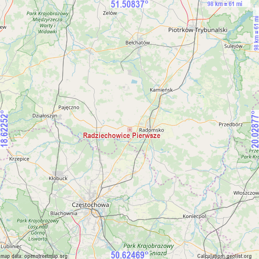
Radziechowice Pierwsze GPS coordinates[2]
51° 4' 7.104" North, 19° 19' 32.304" East
| Map corner | latitude | longitude |
|---|---|---|
| Upper-left | 51.50837°, | 18.62252° |
| Center: | 51.06864°, | 19.32564° |
| Lower-right: | 50.62469°, | 20.02877° |
| Map W x H: | 98.3×98.3 km | = 61.1×61.1mi |
| max Lat: | 54.83135° ⇑53.6% North |
| Radziechowice Pierwsze: | 51.06864° |
| min Lat: | ⇓46.4% South 49.21328° |
| min Long | Radziechowice P | max Long |
| 14.20249° | 19.32564° | 24.03723° |
| W 46%⇐ | ⇒54% E |
Elevation
Elevation of Radziechowice Pierwsze is 210 m = 689 ft, and this is 18.6 m = 61 ft above average elevation for this country.
| Max E: |
974 m = 3196 ft | 36.7% |
| Radziechowice Pierwsze | 210 m 689 ft | |
| Avg. | 191.4 m = 628 ft | |
Min E: |
-3 m = -10 ft | 63.3% |
See also: Poland elevation on elevation.city.
Geographical zone
Radziechowice Pierwsze is located in North temperate zone (between Tropic of Cancer and the Arctic Circle). Distance of this North polar circle is 1722.9 km =1070.6 mi to North.| Distance of | km | miles | from Radziechowice Pierwsze |
|---|---|---|---|
| North Pole | 4328.8 | 2689.8 | to North |
| Arctic Circle | 1722.9 | 1070.6 | to North |
| Tropic Cancer | 3072.4 | 1909.1 | to South |
| Equator | 5678.3 | 3528.3 | to South |


Nearby cities:
15 places around Radziechowice Pierwsze: (largest is in red/bold)
• Bogusławice
13.4 km =8.3 mi,  200°
200°
• Borowno
15.6 km =9.7 mi,  193°
193°
• Dobroszyce
10.3 km =6.4 mi,  35°
35°
• Gidle
15.7 km =9.8 mi,  139°
139°
• Gomunice
16.2 km =10.1 mi,  46°
46°
• Kleszczów
17.3 km =10.7 mi,  355°
355°
• Kruszyna
11.8 km =7.3 mi, 196°
• Kłomnice
16.5 km =10.3 mi,  172°
172°
• Lgota Wielka
8.9 km =5.5 mi,  0°
0°
• Nowa Brzeźnica
10 km =6.2 mi,  278°
278°
• Pławno
13.6 km =8.5 mi, 138°
• Radomsko
8.3 km =5.2 mi,  91°
91°
• Strzelce Wielkie
14.8 km =9.2 mi,  302°
302°
• Sulmierzyce
15.7 km =9.8 mi,  324°
324°
• Łękińsko
16.6 km =10.3 mi,  5°
5°
Sources, notices
• [Note1] Compared only with cities in Poland existing in our database
• [Src1] Map data: © OpenStreetMap contributors (CC-BY-SA)
• [Src2] Other city data from geonames.org with taken over terms of usage.
• [Src3] Geographical zone / Annual Mean Temperature by Robert A. Rohde @ Wikipedia
