Borowno geodata
Borowno (Silesia) is a populated place; located in Poland in Europe/Warsaw (GMT+2) time zone. With population of 1,364 people, there are 2012 cities with bigger population in this country. Compared to other cities in Poland, 56.8% of cities are located further ↑North; 54.8% of cities are located further →East and 73.4% of cities have lower elevation than Borowno. Note1


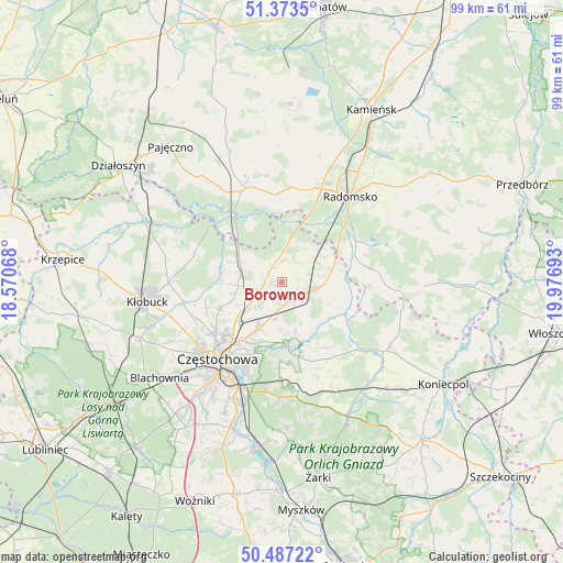
Borowno GPS coordinates[2]
50° 55' 56.892" North, 19° 16' 25.68" East
| Map corner | latitude | longitude |
|---|---|---|
| Upper-left | 51.3735°, | 18.57068° |
| Center: | 50.93247°, | 19.2738° |
| Lower-right: | 50.48722°, | 19.97693° |
| Map W x H: | 98.5×98.5 km | = 61.2×61.2mi |
| max Lat: | 54.83135° ⇑56.8% North |
| Borowno: | 50.93247° |
| min Lat: | ⇓43.2% South 49.21328° |
| min Long | Borowno | max Long |
| 14.20249° | 19.2738° | 24.03723° |
| W 45.2%⇐ | ⇒54.8% E |
Elevation
Elevation of Borowno is 241 m = 791 ft, and this is 49.6 m = 163 ft above average elevation for this country.
| Max E: |
974 m = 3196 ft | 26.6% |
| Borowno | 241 m 791 ft | |
| Avg. | 191.4 m = 628 ft | |
Min E: |
-3 m = -10 ft | 73.4% |
See also: Poland elevation on elevation.city.
Geographical zone
Borowno is located in North temperate zone (between Tropic of Cancer and the Arctic Circle). Distance of this North polar circle is 1738 km =1079.9 mi to North.| Distance of | km | miles | from Borowno |
|---|---|---|---|
| North Pole | 4343.9 | 2699.2 | to North |
| Arctic Circle | 1738 | 1079.9 | to North |
| Tropic Cancer | 3057.2 | 1899.7 | to South |
| Equator | 5663.2 | 3518.9 | to South |


Nearby cities:
15 places around Borowno: (largest is in red/bold)
• Biała Dolna
16.7 km =10.4 mi,  243°
243°
• Bogusławice
2.8 km =1.7 mi,  338°
338°
• Gidle
14.3 km =8.9 mi,  76°
76°
• Kamyk
17.5 km =10.9 mi,  258°
258°
• Kościelec
5.7 km =3.5 mi,  226°
226°
• Kruszyna
3.9 km =2.4 mi,  3°
3°
• Kłomnice
5.9 km =3.7 mi,  101°
101°
• Mstów
11.5 km =7.1 mi,  175°
175°
• Mykanów
5.2 km =3.2 mi, 259°
• Nowa Brzeźnica
17.7 km =11 mi, 339°
• Ostrowy nad Okszą
16.2 km =10.1 mi,  288°
288°
• Pławno
13.7 km =8.5 mi,  68°
68°
• Radziechowice Pierwsze
15.6 km =9.7 mi,  13°
13°
• Rudniki
6.3 km =3.9 mi,  197°
197°
• Rędziny
9.1 km =5.7 mi,  206°
206°
Sources, notices
• [Note1] Compared only with cities in Poland existing in our database
• [Src1] Map data: © OpenStreetMap contributors (CC-BY-SA)
• [Src2] Other city data from geonames.org with taken over terms of usage.
• [Src3] Geographical zone / Annual Mean Temperature by Robert A. Rohde @ Wikipedia
