Krotoszyn geodata
Krotoszyn (Greater Poland) is a seat of a third-order administrative division; located in Poland in Europe/Warsaw (GMT+2) time zone. With population of 29,231 people, there are 168 cities with bigger population in this country. Compared to other cities in Poland, 60.1% of cities are located further ↓South; 80.5% of cities are located further →East and 65.2% of cities have higher elevation than Krotoszyn. Note1


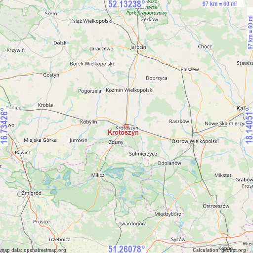
Krotoszyn GPS coordinates[2]
51° 41' 55.248" North, 17° 26' 14.568" East
| Map corner | latitude | longitude |
|---|---|---|
| Upper-left | 52.13238°, | 16.73426° |
| Center: | 51.69868°, | 17.43738° |
| Lower-right: | 51.26078°, | 18.14051° |
| Map W x H: | 96.9×96.9 km | = 60.2×60.2mi |
| max Lat: | 54.83135° ⇑39.9% North |
| Krotoszyn: | 51.69868° |
| min Lat: | ⇓60.1% South 49.21328° |
| min Long | Krotoszyn | max Long |
| 14.20249° | 17.43738° | 24.03723° |
| W 19.5%⇐ | ⇒80.5% E |
Elevation
Elevation of Krotoszyn is 132 m = 433 ft, and this is 59.4 m = 195 ft below average elevation for this country.
| Max E: |
974 m = 3196 ft | 65.2% |
| Avg. | 191.4 m = 628 ft | |
| Krotoszyn | 132 m = 433 ft | |
Min E: |
-3 m = -10 ft | 34.8% |
See also: Poland elevation on elevation.city.
Geographical zone
Krotoszyn is located in North temperate zone (between Tropic of Cancer and the Arctic Circle). Distance of this North polar circle is 1652.8 km =1027 mi to North.| Distance of | km | miles | from Krotoszyn |
|---|---|---|---|
| North Pole | 4258.7 | 2646.2 | to North |
| Arctic Circle | 1652.8 | 1027 | to North |
| Tropic Cancer | 3142.4 | 1952.6 | to South |
| Equator | 5748.4 | 3571.9 | to South |


Nearby cities:
15 places around Krotoszyn: (largest is in red/bold)
• Cieszków
9.3 km =5.8 mi,  216°
216°
• Gorzyce Wielkie
21.3 km =13.2 mi,  108°
108°
• Jutrosin
19.2 km =11.9 mi,  253°
253°
• Kobylin
14.6 km =9.1 mi,  277°
277°
• Korytnica
20.4 km =12.7 mi,  67°
67°
• Koźmin Wielkopolski
14.3 km =8.9 mi,  4°
4°
• Moszczanka
20.8 km =12.9 mi,  83°
83°
• Odolanów
21.4 km =13.3 mi,  130°
130°
• Pogorzela
19.8 km =12.3 mi,  313°
313°
• Przybysławice
19 km =11.8 mi,  87°
87°
• Raszków
20 km =12.4 mi, 83°
• Rozdrażew
10.4 km =6.5 mi,  26°
26°
• Sulmierzyce
12.2 km =7.6 mi,  148°
148°
• Wierzbno
17.3 km =10.7 mi, 113°
• Zduny
7.2 km =4.5 mi, 215°
Sources, notices
• [Note1] Compared only with cities in Poland existing in our database
• [Src1] Map data: © OpenStreetMap contributors (CC-BY-SA)
• [Src2] Other city data from geonames.org with taken over terms of usage.
• [Src3] Geographical zone / Annual Mean Temperature by Robert A. Rohde @ Wikipedia
