Cieszków geodata
Cieszków (Lower Silesia) is a populated place; located in Poland in Europe/Warsaw (GMT+2) time zone. With population of 1,800 people, there are 1605 cities with bigger population in this country. Compared to other cities in Poland, 58.6% of cities are located further ↓South; 81.1% of cities are located further →East and 64.7% of cities have higher elevation than Cieszków. Note1


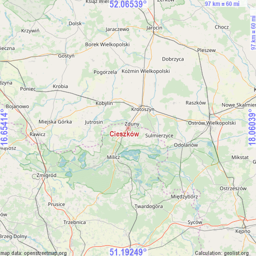
Cieszków GPS coordinates[2]
51° 37' 51.744" North, 17° 21' 26.136" East
| Map corner | latitude | longitude |
|---|---|---|
| Upper-left | 52.06539°, | 16.65414° |
| Center: | 51.63104°, | 17.35726° |
| Lower-right: | 51.19249°, | 18.06039° |
| Map W x H: | 97.1×97.1 km | = 60.3×60.3mi |
| max Lat: | 54.83135° ⇑41.4% North |
| Cieszków: | 51.63104° |
| min Lat: | ⇓58.6% South 49.21328° |
| min Long | Cieszków | max Long |
| 14.20249° | 17.35726° | 24.03723° |
| W 18.9%⇐ | ⇒81.1% E |
Elevation
Elevation of Cieszków is 134 m = 440 ft, and this is 57.4 m = 188 ft below average elevation for this country.
| Max E: |
974 m = 3196 ft | 64.7% |
| Avg. | 191.4 m = 628 ft | |
| Cieszków | 134 m = 440 ft | |
Min E: |
-3 m = -10 ft | 35.3% |
See also: Poland elevation on elevation.city.
Geographical zone
Cieszków is located in North temperate zone (between Tropic of Cancer and the Arctic Circle). Distance of this North polar circle is 1660.3 km =1031.7 mi to North.| Distance of | km | miles | from Cieszków |
|---|---|---|---|
| North Pole | 4266.2 | 2650.9 | to North |
| Arctic Circle | 1660.3 | 1031.7 | to North |
| Tropic Cancer | 3134.9 | 1947.9 | to South |
| Equator | 5740.8 | 3567.2 | to South |


Nearby cities:
15 places around Cieszków: (largest is in red/bold)
• Garki
22.3 km =13.9 mi,  117°
117°
• Jutrosin
13.1 km =8.1 mi,  279°
279°
• Kobylin
13.1 km =8.1 mi,  316°
316°
• Konary
22 km =13.7 mi, 277°
• Koźmin Wielkopolski
22.8 km =14.2 mi,  16°
16°
• Krotoszyn
9.3 km =5.8 mi,  36°
36°
• Krośnice
17.2 km =10.7 mi,  179°
179°
• Milicz
12.9 km =8 mi,  207°
207°
• Pakosław
20.7 km =12.9 mi,  264°
264°
• Pępowo
21.8 km =13.5 mi,  313°
313°
• Rozdrażew
19.6 km =12.2 mi,  31°
31°
• Sulmierzyce
12.3 km =7.6 mi,  103°
103°
• Sułów
19.6 km =12.2 mi,  221°
221°
• Wierzbno
21.4 km =13.3 mi,  87°
87°
• Zduny
2.1 km =1.3 mi, 39°
Sources, notices
• [Note1] Compared only with cities in Poland existing in our database
• [Src1] Map data: © OpenStreetMap contributors (CC-BY-SA)
• [Src2] Other city data from geonames.org with taken over terms of usage.
• [Src3] Geographical zone / Annual Mean Temperature by Robert A. Rohde @ Wikipedia
