Sulmierzyce geodata
Sulmierzyce (Greater Poland) is a populated place; located in Poland in Europe/Warsaw (GMT+2) time zone. With population of 2,829 people, there are 1109 cities with bigger population in this country. Compared to other cities in Poland, 58.1% of cities are located further ↓South; 79.6% of cities are located further →East and 67.8% of cities have higher elevation than Sulmierzyce. Note1
Administrative division(s):
- Level 1: Greater Poland
- Level 2: Powiat krotoszyński
- Level 3: Sulmierzyce


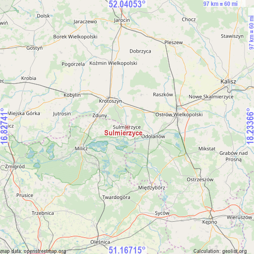
Sulmierzyce GPS coordinates[2]
51° 36' 21.384" North, 17° 31' 49.908" East
| Map corner | latitude | longitude |
|---|---|---|
| Upper-left | 52.04053°, | 16.82741° |
| Center: | 51.60594°, | 17.53053° |
| Lower-right: | 51.16715°, | 18.23366° |
| Map W x H: | 97.1×97.1 km | = 60.3×60.3mi |
| max Lat: | 54.83135° ⇑41.9% North |
| Sulmierzyce: | 51.60594° |
| min Lat: | ⇓58.1% South 49.21328° |
| min Long | Sulmierzyce | max Long |
| 14.20249° | 17.53053° | 24.03723° |
| W 20.4%⇐ | ⇒79.6% E |
Elevation
Elevation of Sulmierzyce is 126 m = 413 ft, and this is 65.4 m = 215 ft below average elevation for this country.
| Max E: |
974 m = 3196 ft | 67.8% |
| Avg. | 191.4 m = 628 ft | |
| Sulmierzyce | 126 m = 413 ft | |
Min E: |
-3 m = -10 ft | 32.2% |
See also: Poland elevation on elevation.city.
Geographical zone
Sulmierzyce is located in North temperate zone (between Tropic of Cancer and the Arctic Circle). Distance of this North polar circle is 1663.1 km =1033.4 mi to North.| Distance of | km | miles | from Sulmierzyce |
|---|---|---|---|
| North Pole | 4269 | 2652.6 | to North |
| Arctic Circle | 1663.1 | 1033.4 | to North |
| Tropic Cancer | 3132.1 | 1946.2 | to South |
| Equator | 5738 | 3565.4 | to South |


Nearby cities:
15 places around Sulmierzyce: (largest is in red/bold)
• Cieszków
12.3 km =7.6 mi,  283°
283°
• Garki
10.9 km =6.8 mi,  134°
134°
• Gorzyce Wielkie
14.2 km =8.8 mi,  75°
75°
• Janków Przygodzki
17.8 km =11.1 mi,  92°
92°
• Krotoszyn
12.2 km =7.6 mi,  328°
328°
• Krośnice
18.7 km =11.6 mi,  219°
219°
• Moszczanka
19 km =11.8 mi,  48°
48°
• Odolanów
10.5 km =6.5 mi,  109°
109°
• Ostrów Wielkopolski
19.8 km =12.3 mi,  74°
74°
• Przybysławice
16.8 km =10.4 mi, 48°
• Raszków
18.4 km =11.4 mi, 47°
• Rozdrażew
19.7 km =12.2 mi,  354°
354°
• Sośnie
16.4 km =10.2 mi,  154°
154°
• Wierzbno
10.1 km =6.3 mi, 69°
• Zduny
11.5 km =7.1 mi,  292°
292°
Sources, notices
• [Note1] Compared only with cities in Poland existing in our database
• [Src1] Map data: © OpenStreetMap contributors (CC-BY-SA)
• [Src2] Other city data from geonames.org with taken over terms of usage.
• [Src3] Geographical zone / Annual Mean Temperature by Robert A. Rohde @ Wikipedia
