Rozdrażew geodata
Rozdrażew (Greater Poland) is a seat of a third-order administrative division; located in Poland in Europe/Warsaw (GMT+2) time zone. With population of 1,800 people, there are 1605 cities with bigger population in this country. Compared to other cities in Poland, 61.7% of cities are located further ↓South; 79.7% of cities are located further →East and 61.5% of cities have higher elevation than Rozdrażew. Note1


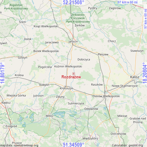
Rozdrażew GPS coordinates[2]
51° 46' 55.848" North, 17° 30' 17.676" East
| Map corner | latitude | longitude |
|---|---|---|
| Upper-left | 52.21508°, | 16.80179° |
| Center: | 51.78218°, | 17.50491° |
| Lower-right: | 51.34509°, | 18.20804° |
| Map W x H: | 96.7×96.7 km | = 60.1×60.1mi |
| max Lat: | 54.83135° ⇑38.3% North |
| Rozdrażew: | 51.78218° |
| min Lat: | ⇓61.7% South 49.21328° |
| min Long | Rozdrażew | max Long |
| 14.20249° | 17.50491° | 24.03723° |
| W 20.3%⇐ | ⇒79.7% E |
Elevation
Elevation of Rozdrażew is 143 m = 469 ft, and this is 48.4 m = 159 ft below average elevation for this country.
| Max E: |
974 m = 3196 ft | 61.5% |
| Avg. | 191.4 m = 628 ft | |
| Rozdrażew | 143 m = 469 ft | |
Min E: |
-3 m = -10 ft | 38.5% |
See also: Poland elevation on elevation.city.
Geographical zone
Rozdrażew is located in North temperate zone (between Tropic of Cancer and the Arctic Circle). Distance of this North polar circle is 1643.5 km =1021.2 mi to North.| Distance of | km | miles | from Rozdrażew |
|---|---|---|---|
| North Pole | 4249.4 | 2640.5 | to North |
| Arctic Circle | 1643.5 | 1021.2 | to North |
| Tropic Cancer | 3151.7 | 1958.4 | to South |
| Equator | 5757.6 | 3577.6 | to South |


Nearby cities:
15 places around Rozdrażew: (largest is in red/bold)
• Dobrzyca
11.6 km =7.2 mi,  35°
35°
• Golina
14.8 km =9.2 mi,  354°
354°
• Korytnica
14.2 km =8.8 mi,  95°
95°
• Kotlin
18.1 km =11.2 mi,  32°
32°
• Koźmin Wielkopolski
6.1 km =3.8 mi,  324°
324°
• Krotoszyn
10.4 km =6.5 mi,  206°
206°
• Moszczanka
17.5 km =10.9 mi,  113°
113°
• Pogorzela
19.4 km =12.1 mi,  283°
283°
• Przybysławice
16.6 km =10.3 mi,  120°
120°
• Raszków
16.8 km =10.4 mi, 115°
• Sośnica
14.9 km =9.3 mi,  53°
53°
• Wierzbno
19.6 km =12.2 mi,  145°
145°
• Witaszyce
18.1 km =11.2 mi,  12°
12°
• Zakrzew
15.9 km =9.9 mi, 7°
• Zduny
17.5 km =10.9 mi, 210°
Sources, notices
• [Note1] Compared only with cities in Poland existing in our database
• [Src1] Map data: © OpenStreetMap contributors (CC-BY-SA)
• [Src2] Other city data from geonames.org with taken over terms of usage.
• [Src3] Geographical zone / Annual Mean Temperature by Robert A. Rohde @ Wikipedia
