Kościan geodata
Kościan (Greater Poland) is a seat of a third-order administrative division; located in Poland in Europe/Warsaw (GMT+2) time zone. With population of 24,096 people, there are 201 cities with bigger population in this country. Compared to other cities in Poland, 67.5% of cities are located further ↓South; 88.5% of cities are located further →East and 91.1% of cities have higher elevation than Kościan. Note1


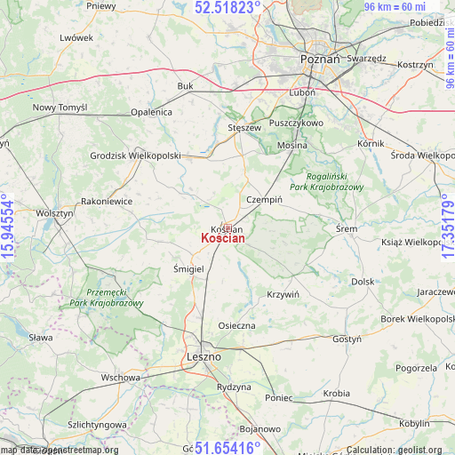
Kościan GPS coordinates[2]
52° 5' 17.844" North, 16° 38' 55.176" East
| Map corner | latitude | longitude |
|---|---|---|
| Upper-left | 52.51823°, | 15.94554° |
| Center: | 52.08829°, | 16.64866° |
| Lower-right: | 51.65416°, | 17.35179° |
| Map W x H: | 96.1×96.1 km | = 59.7×59.7mi |
| max Lat: | 54.83135° ⇑32.5% North |
| Kościan: | 52.08829° |
| min Lat: | ⇓67.5% South 49.21328° |
| min Long | Kościan | max Long |
| 14.20249° | 16.64866° | 24.03723° |
| W 11.5%⇐ | ⇒88.5% E |
Elevation
Elevation of Kościan is 70 m = 230 ft, and this is 121.4 m = 398 ft below average elevation for this country.
| Max E: |
974 m = 3196 ft | 91.1% |
| Avg. | 191.4 m = 628 ft | |
| Kościan | 70 m = 230 ft | |
Min E: |
-3 m = -10 ft | 8.9% |
See also: Poland elevation on elevation.city.
Geographical zone
Kościan is located in North temperate zone (between Tropic of Cancer and the Arctic Circle). Distance of this North polar circle is 1609.5 km =1000.1 mi to North.| Distance of | km | miles | from Kościan |
|---|---|---|---|
| North Pole | 4215.4 | 2619.3 | to North |
| Arctic Circle | 1609.5 | 1000.1 | to North |
| Tropic Cancer | 3185.8 | 1979.6 | to South |
| Equator | 5791.7 | 3598.8 | to South |


Nearby cities:
15 places around Kościan: (largest is in red/bold)
• Bojanowo Stare
11.5 km =7.1 mi,  202°
202°
• Brodnica
17.6 km =10.9 mi,  70°
70°
• Czempiń
10 km =6.2 mi,  51°
51°
• Granowo
17 km =10.6 mi,  331°
331°
• Kamieniec
15.4 km =9.6 mi,  304°
304°
• Krosinko
19.8 km =12.3 mi,  34°
34°
• Krosno
19.6 km =12.2 mi,  39°
39°
• Krzywiń
18.2 km =11.3 mi,  139°
139°
• Lipno
19.8 km =12.3 mi, 196°
• Lubiń
21.9 km =13.6 mi,  128°
128°
• Osieczna
20.6 km =12.8 mi,  174°
174°
• Pecna
14.8 km =9.2 mi, 44°
• Stęszew
22 km =13.7 mi,  9°
9°
• Wielichowo
20.5 km =12.7 mi,  278°
278°
• Śmigiel
11.8 km =7.3 mi,  224°
224°
Sources, notices
• [Note1] Compared only with cities in Poland existing in our database
• [Src1] Map data: © OpenStreetMap contributors (CC-BY-SA)
• [Src2] Other city data from geonames.org with taken over terms of usage.
• [Src3] Geographical zone / Annual Mean Temperature by Robert A. Rohde @ Wikipedia
