Lipno geodata
Lipno (Greater Poland) is a seat of a third-order administrative division; located in Poland in Europe/Warsaw (GMT+2) time zone. With population of 1,176 people, there are 2233 cities with bigger population in this country. Compared to other cities in Poland, 64.1% of cities are located further ↓South; 89.1% of cities are located further →East and 73.1% of cities have higher elevation than Lipno. Note1


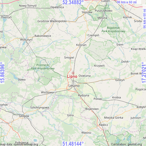
Lipno GPS coordinates[2]
51° 55' 1.992" North, 16° 34' 1.488" East
| Map corner | latitude | longitude |
|---|---|---|
| Upper-left | 52.34882°, | 15.86396° |
| Center: | 51.91722°, | 16.56708° |
| Lower-right: | 51.48144°, | 17.27021° |
| Map W x H: | 96.4×96.4 km | = 59.9×59.9mi |
| max Lat: | 54.83135° ⇑35.9% North |
| Lipno: | 51.91722° |
| min Lat: | ⇓64.1% South 49.21328° |
| min Long | Lipno | max Long |
| 14.20249° | 16.56708° | 24.03723° |
| W 10.9%⇐ | ⇒89.1% E |
Elevation
Elevation of Lipno is 115 m = 377 ft, and this is 76.4 m = 251 ft below average elevation for this country.
| Max E: |
974 m = 3196 ft | 73.1% |
| Avg. | 191.4 m = 628 ft | |
| Lipno | 115 m = 377 ft | |
Min E: |
-3 m = -10 ft | 26.9% |
See also: Poland elevation on elevation.city.
Geographical zone
Lipno is located in North temperate zone (between Tropic of Cancer and the Arctic Circle). Distance of this North polar circle is 1628.5 km =1011.9 mi to North.| Distance of | km | miles | from Lipno |
|---|---|---|---|
| North Pole | 4234.4 | 2631.1 | to North |
| Arctic Circle | 1628.5 | 1011.9 | to North |
| Tropic Cancer | 3166.7 | 1967.7 | to South |
| Equator | 5772.7 | 3587 | to South |


Nearby cities:
15 places around Lipno: (largest is in red/bold)
• Bojanowo Stare
8.5 km =5.3 mi,  7°
7°
• Chróścina
19.4 km =12.1 mi,  185°
185°
• Kościan
19.8 km =12.3 mi,  16°
16°
• Krzemieniewo
19.4 km =12.1 mi,  109°
109°
• Krzywiń
18.1 km =11.2 mi,  73°
73°
• Leszno
8.6 km =5.3 mi,  176°
176°
• Lubiń
23.3 km =14.5 mi,  76°
76°
• Osieczna
7.8 km =4.8 mi,  100°
100°
• Przemęt
20.8 km =12.9 mi,  299°
299°
• Rydzyna
16.1 km =10 mi,  154°
154°
• Wilkowice
4.2 km =2.6 mi,  212°
212°
• Wschowa
21.1 km =13.1 mi,  234°
234°
• Włoszakowice
13.9 km =8.6 mi,  274°
274°
• Śmigiel
11 km =6.8 mi,  345°
345°
• Święciechowa
8.4 km =5.2 mi, 214°
Sources, notices
• [Note1] Compared only with cities in Poland existing in our database
• [Src1] Map data: © OpenStreetMap contributors (CC-BY-SA)
• [Src2] Other city data from geonames.org with taken over terms of usage.
• [Src3] Geographical zone / Annual Mean Temperature by Robert A. Rohde @ Wikipedia
