Bojanowo Stare geodata
Bojanowo Stare (Greater Poland) is a populated place; located in Poland in Europe/Warsaw (GMT+2) time zone. With population of 1,692 people, there are 1703 cities with bigger population in this country. Compared to other cities in Poland, 65.7% of cities are located further ↓South; 88.9% of cities are located further →East and 87.2% of cities have higher elevation than Bojanowo Stare. Note1


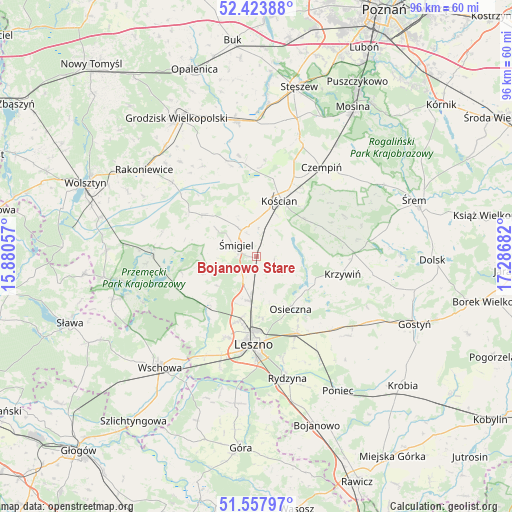
Bojanowo Stare GPS coordinates[2]
51° 59' 34.872" North, 16° 35' 1.284" East
| Map corner | latitude | longitude |
|---|---|---|
| Upper-left | 52.42388°, | 15.88057° |
| Center: | 51.99302°, | 16.58369° |
| Lower-right: | 51.55797°, | 17.28682° |
| Map W x H: | 96.3×96.3 km | = 59.8×59.8mi |
| max Lat: | 54.83135° ⇑34.3% North |
| Bojanowo Stare: | 51.99302° |
| min Lat: | ⇓65.7% South 49.21328° |
| min Long | Bojanowo Stare | max Long |
| 14.20249° | 16.58369° | 24.03723° |
| W 11.1%⇐ | ⇒88.9% E |
Elevation
Elevation of Bojanowo Stare is 84 m = 276 ft, and this is 107.4 m = 352 ft below average elevation for this country.
| Max E: |
974 m = 3196 ft | 87.2% |
| Avg. | 191.4 m = 628 ft | |
| Bojanowo Stare | 84 m = 276 ft | |
Min E: |
-3 m = -10 ft | 12.8% |
See also: Poland elevation on elevation.city.
Geographical zone
Bojanowo Stare is located in North temperate zone (between Tropic of Cancer and the Arctic Circle). Distance of this North polar circle is 1620.1 km =1006.7 mi to North.| Distance of | km | miles | from Bojanowo Stare |
|---|---|---|---|
| North Pole | 4226 | 2625.9 | to North |
| Arctic Circle | 1620.1 | 1006.7 | to North |
| Tropic Cancer | 3175.2 | 1973 | to South |
| Equator | 5781.1 | 3592.2 | to South |


Nearby cities:
15 places around Bojanowo Stare: (largest is in red/bold)
• Czempiń
20.8 km =12.9 mi,  36°
36°
• Kamieniec
21 km =13 mi,  336°
336°
• Kościan
11.5 km =7.1 mi,  22°
22°
• Krzemieniewo
22.7 km =14.1 mi,  131°
131°
• Krzywiń
16.5 km =10.3 mi,  101°
101°
• Leszno
17 km =10.6 mi,  182°
182°
• Lipno
8.5 km =5.3 mi,  187°
187°
• Lubiń
21.8 km =13.5 mi, 98°
• Osieczna
11.8 km =7.3 mi,  146°
146°
• Przemęt
19.4 km =12.1 mi,  274°
274°
• Wielichowo
20.9 km =13 mi,  310°
310°
• Wilkowice
12.5 km =7.8 mi,  195°
195°
• Włoszakowice
16.7 km =10.4 mi,  244°
244°
• Śmigiel
4.5 km =2.8 mi,  300°
300°
• Święciechowa
16.4 km =10.2 mi, 200°
Sources, notices
• [Note1] Compared only with cities in Poland existing in our database
• [Src1] Map data: © OpenStreetMap contributors (CC-BY-SA)
• [Src2] Other city data from geonames.org with taken over terms of usage.
• [Src3] Geographical zone / Annual Mean Temperature by Robert A. Rohde @ Wikipedia
