Kamieniec geodata
Kamieniec (Greater Poland) is a populated place; located in Poland in Europe/Warsaw (GMT+2) time zone. With population of 1,098 people, there are 2359 cities with bigger population in this country. Compared to other cities in Poland, 69.2% of cities are located further ↓South; 89.7% of cities are located further →East and 91.1% of cities have higher elevation than Kamieniec. Note1


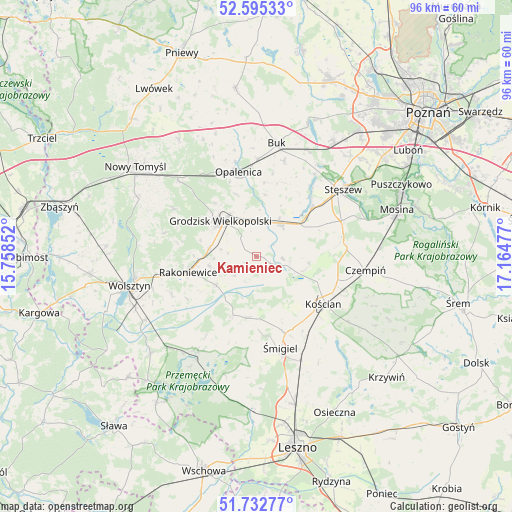
Kamieniec GPS coordinates[2]
52° 9' 58.104" North, 16° 27' 41.904" East
| Map corner | latitude | longitude |
|---|---|---|
| Upper-left | 52.59533°, | 15.75852° |
| Center: | 52.16614°, | 16.46164° |
| Lower-right: | 51.73277°, | 17.16477° |
| Map W x H: | 95.9×95.9 km | = 59.6×59.6mi |
| max Lat: | 54.83135° ⇑30.8% North |
| Kamieniec: | 52.16614° |
| min Lat: | ⇓69.2% South 49.21328° |
| min Long | Kamieniec | max Long |
| 14.20249° | 16.46164° | 24.03723° |
| W 10.3%⇐ | ⇒89.7% E |
Elevation
Elevation of Kamieniec is 70 m = 230 ft, and this is 121.4 m = 398 ft below average elevation for this country.
| Max E: |
974 m = 3196 ft | 91.1% |
| Avg. | 191.4 m = 628 ft | |
| Kamieniec | 70 m = 230 ft | |
Min E: |
-3 m = -10 ft | 8.9% |
See also: Poland elevation on elevation.city.
Geographical zone
Kamieniec is located in North temperate zone (between Tropic of Cancer and the Arctic Circle). Distance of this North polar circle is 1600.8 km =994.7 mi to North.| Distance of | km | miles | from Kamieniec |
|---|---|---|---|
| North Pole | 4206.7 | 2613.9 | to North |
| Arctic Circle | 1600.8 | 994.7 | to North |
| Tropic Cancer | 3194.4 | 1984.9 | to South |
| Equator | 5800.3 | 3604.1 | to South |


Nearby cities:
15 places around Kamieniec: (largest is in red/bold)
• Bojanowo Stare
21 km =13 mi,  156°
156°
• Buk
21.4 km =13.3 mi,  10°
10°
• Czempiń
20.8 km =12.9 mi,  96°
96°
• Granowo
7.7 km =4.8 mi,  36°
36°
• Grodzisk Wielkopolski
9.5 km =5.9 mi,  316°
316°
• Jabłonna
17.9 km =11.1 mi,  284°
284°
• Kościan
15.4 km =9.6 mi,  124°
124°
• Kuślin
24.1 km =15 mi,  335°
335°
• Opalenica
16.2 km =10.1 mi,  348°
348°
• Pecna
23.2 km =14.4 mi,  85°
85°
• Przemęt
20.7 km =12.9 mi,  211°
211°
• Rakoniewice
13.2 km =8.2 mi,  256°
256°
• Stęszew
20.9 km =13 mi,  51°
51°
• Wielichowo
9.4 km =5.8 mi,  233°
233°
• Śmigiel
17.6 km =10.9 mi,  165°
165°
Sources, notices
• [Note1] Compared only with cities in Poland existing in our database
• [Src1] Map data: © OpenStreetMap contributors (CC-BY-SA)
• [Src2] Other city data from geonames.org with taken over terms of usage.
• [Src3] Geographical zone / Annual Mean Temperature by Robert A. Rohde @ Wikipedia
