Wielichowo geodata
Wielichowo (Greater Poland) is a seat of a third-order administrative division; located in Poland in Europe/Warsaw (GMT+2) time zone. With population of 1,736 people, there are 1654 cities with bigger population in this country. Compared to other cities in Poland, 68.2% of cities are located further ↓South; 90.5% of cities are located further →East and 91.1% of cities have higher elevation than Wielichowo. Note1


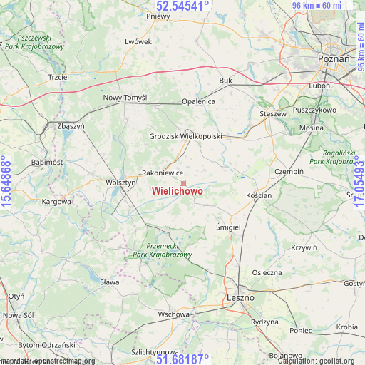
Wielichowo GPS coordinates[2]
52° 6' 56.628" North, 16° 21' 6.48" East
| Map corner | latitude | longitude |
|---|---|---|
| Upper-left | 52.54541°, | 15.64868° |
| Center: | 52.11573°, | 16.3518° |
| Lower-right: | 51.68187°, | 17.05493° |
| Map W x H: | 96×96 km | = 59.7×59.7mi |
| max Lat: | 54.83135° ⇑31.8% North |
| Wielichowo: | 52.11573° |
| min Lat: | ⇓68.2% South 49.21328° |
| min Long | Wielichowo | max Long |
| 14.20249° | 16.3518° | 24.03723° |
| W 9.5%⇐ | ⇒90.5% E |
Elevation
Elevation of Wielichowo is 70 m = 230 ft, and this is 121.4 m = 398 ft below average elevation for this country.
| Max E: |
974 m = 3196 ft | 91.1% |
| Avg. | 191.4 m = 628 ft | |
| Wielichowo | 70 m = 230 ft | |
Min E: |
-3 m = -10 ft | 8.9% |
See also: Poland elevation on elevation.city.
Geographical zone
Wielichowo is located in North temperate zone (between Tropic of Cancer and the Arctic Circle). Distance of this North polar circle is 1606.4 km =998.2 mi to North.| Distance of | km | miles | from Wielichowo |
|---|---|---|---|
| North Pole | 4212.3 | 2617.4 | to North |
| Arctic Circle | 1606.4 | 998.2 | to North |
| Tropic Cancer | 3188.8 | 1981.4 | to South |
| Equator | 5794.7 | 3600.7 | to South |


Nearby cities:
15 places around Wielichowo: (largest is in red/bold)
• Bojanowo Stare
20.9 km =13 mi,  130°
130°
• Brenno
23.4 km =14.5 mi,  203°
203°
• Granowo
16.9 km =10.5 mi,  45°
45°
• Grodzisk Wielkopolski
12.5 km =7.8 mi,  4°
4°
• Jabłonna
14.1 km =8.8 mi,  315°
315°
• Kamieniec
9.4 km =5.8 mi, 53°
• Kościan
20.5 km =12.7 mi,  98°
98°
• Opalenica
21.9 km =13.6 mi,  10°
10°
• Przemęt
12.5 km =7.8 mi, 196°
• Rakoniewice
5.9 km =3.7 mi,  295°
295°
• Siedlec
23.9 km =14.9 mi,  275°
275°
• Wijewo
24.9 km =15.5 mi,  207°
207°
• Wolsztyn
16 km =9.9 mi,  269°
269°
• Włoszakowice
20.9 km =13 mi,  177°
177°
• Śmigiel
16.5 km =10.3 mi, 133°
Sources, notices
• [Note1] Compared only with cities in Poland existing in our database
• [Src1] Map data: © OpenStreetMap contributors (CC-BY-SA)
• [Src2] Other city data from geonames.org with taken over terms of usage.
• [Src3] Geographical zone / Annual Mean Temperature by Robert A. Rohde @ Wikipedia
