Osieczna geodata
Osieczna (Greater Poland) is a seat of a third-order administrative division; located in Poland in Europe/Warsaw (GMT+2) time zone. With population of 2,132 people, there are 1393 cities with bigger population in this country. Compared to other cities in Poland, 63.7% of cities are located further ↓South; 88.2% of cities are located further →East and 88.4% of cities have higher elevation than Osieczna. Note1


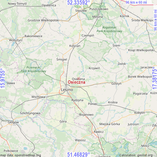
Osieczna GPS coordinates[2]
51° 54' 15.12" North, 16° 40' 43.032" East
| Map corner | latitude | longitude |
|---|---|---|
| Upper-left | 52.33592°, | 15.9755° |
| Center: | 51.9042°, | 16.67862° |
| Lower-right: | 51.46829°, | 17.38175° |
| Map W x H: | 96.5×96.5 km | = 60×60mi |
| max Lat: | 54.83135° ⇑36.3% North |
| Osieczna: | 51.9042° |
| min Lat: | ⇓63.7% South 49.21328° |
| min Long | Osieczna | max Long |
| 14.20249° | 16.67862° | 24.03723° |
| W 11.8%⇐ | ⇒88.2% E |
Elevation
Elevation of Osieczna is 80 m = 262 ft, and this is 111.4 m = 365 ft below average elevation for this country.
| Max E: |
974 m = 3196 ft | 88.4% |
| Avg. | 191.4 m = 628 ft | |
| Osieczna | 80 m = 262 ft | |
Min E: |
-3 m = -10 ft | 11.6% |
See also: Poland elevation on elevation.city.
Geographical zone
Osieczna is located in North temperate zone (between Tropic of Cancer and the Arctic Circle). Distance of this North polar circle is 1630 km =1012.8 mi to North.| Distance of | km | miles | from Osieczna |
|---|---|---|---|
| North Pole | 4235.9 | 2632.1 | to North |
| Arctic Circle | 1630 | 1012.8 | to North |
| Tropic Cancer | 3165.3 | 1966.8 | to South |
| Equator | 5771.2 | 3586.1 | to South |


Nearby cities:
15 places around Osieczna: (largest is in red/bold)
• Bojanowo
22.4 km =13.9 mi,  167°
167°
• Bojanowo Stare
11.8 km =7.3 mi,  326°
326°
• Chróścina
20.2 km =12.6 mi,  208°
208°
• Kościan
20.6 km =12.8 mi,  354°
354°
• Krzemieniewo
11.8 km =7.3 mi,  115°
115°
• Krzywiń
11.7 km =7.3 mi,  55°
55°
• Leszno
10.1 km =6.3 mi,  225°
225°
• Lipno
7.8 km =4.8 mi,  280°
280°
• Lubiń
16.5 km =10.3 mi,  65°
65°
• Poniec
18 km =11.2 mi,  150°
150°
• Rydzyna
13.1 km =8.1 mi,  183°
183°
• Wilkowice
10.1 km =6.3 mi,  257°
257°
• Włoszakowice
21.7 km =13.5 mi, 276°
• Śmigiel
16 km =9.9 mi,  319°
319°
• Święciechowa
13.5 km =8.4 mi,  246°
246°
Sources, notices
• [Note1] Compared only with cities in Poland existing in our database
• [Src1] Map data: © OpenStreetMap contributors (CC-BY-SA)
• [Src2] Other city data from geonames.org with taken over terms of usage.
• [Src3] Geographical zone / Annual Mean Temperature by Robert A. Rohde @ Wikipedia
