Konopiska geodata
Konopiska (Silesia) is a populated place; located in Poland in Europe/Warsaw (GMT+2) time zone. With population of 2,901 people, there are 1089 cities with bigger population in this country. Compared to other cities in Poland, 62.2% of cities are located further ↑North; 59.9% of cities are located further →East and 82.8% of cities have lower elevation than Konopiska. Note1


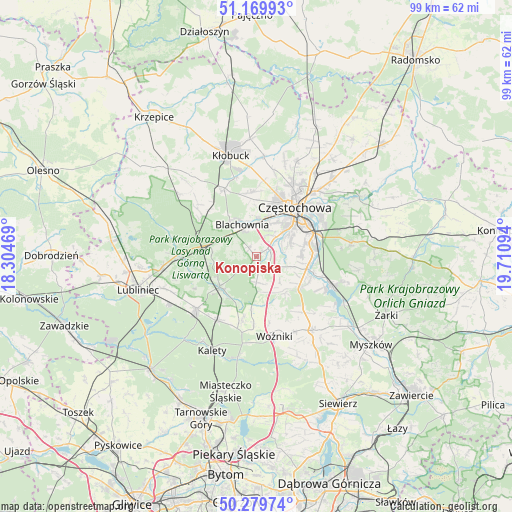
Konopiska GPS coordinates[2]
50° 43' 37.02" North, 19° 0' 28.116" East
| Map corner | latitude | longitude |
|---|---|---|
| Upper-left | 51.16993°, | 18.30469° |
| Center: | 50.72695°, | 19.00781° |
| Lower-right: | 50.27974°, | 19.71094° |
| Map W x H: | 99×99 km | = 61.5×61.5mi |
| max Lat: | 54.83135° ⇑62.2% North |
| Konopiska: | 50.72695° |
| min Lat: | ⇓37.8% South 49.21328° |
| min Long | Konopiska | max Long |
| 14.20249° | 19.00781° | 24.03723° |
| W 40.1%⇐ | ⇒59.9% E |
Elevation
Elevation of Konopiska is 279 m = 915 ft, and this is 87.6 m = 287 ft above average elevation for this country.
| Max E: |
974 m = 3196 ft | 17.2% |
| Konopiska | 279 m 915 ft | |
| Avg. | 191.4 m = 628 ft | |
Min E: |
-3 m = -10 ft | 82.8% |
See also: Poland elevation on elevation.city.
Geographical zone
Konopiska is located in North temperate zone (between Tropic of Cancer and the Arctic Circle). Distance of this North polar circle is 1760.9 km =1094.2 mi to North.| Distance of | km | miles | from Konopiska |
|---|---|---|---|
| North Pole | 4366.8 | 2713.4 | to North |
| Arctic Circle | 1760.9 | 1094.2 | to North |
| Tropic Cancer | 3034.4 | 1885.5 | to South |
| Equator | 5640.3 | 3504.7 | to South |


Nearby cities:
15 places around Konopiska: (largest is in red/bold)
• Blachownia
6.7 km =4.2 mi,  332°
332°
• Boronów
9.2 km =5.7 mi,  230°
230°
• Częstochowa
11.3 km =7 mi,  46°
46°
• Herby
8.9 km =5.5 mi,  289°
289°
• Huta Stara B
8.9 km =5.5 mi,  82°
82°
• Jastrząb
13.8 km =8.6 mi,  117°
117°
• Kalej
12.3 km =7.6 mi,  352°
352°
• Kamienica
10.2 km =6.3 mi,  185°
185°
• Kamienica Polska
10.2 km =6.3 mi,  127°
127°
• Lubsza
13.7 km =8.5 mi,  182°
182°
• Poczesna
9 km =5.6 mi,  98°
98°
• Psary
12.8 km =8 mi, 192°
• Rudnik Wielki
9 km =5.6 mi,  141°
141°
• Siedlec Duży
13.9 km =8.6 mi, 141°
• Starcza
7.4 km =4.6 mi,  161°
161°
Sources, notices
• [Note1] Compared only with cities in Poland existing in our database
• [Src1] Map data: © OpenStreetMap contributors (CC-BY-SA)
• [Src2] Other city data from geonames.org with taken over terms of usage.
• [Src3] Geographical zone / Annual Mean Temperature by Robert A. Rohde @ Wikipedia
