Blachownia geodata
Blachownia (Silesia) is a seat of a third-order administrative division; located in Poland in Europe/Warsaw (GMT+2) time zone. With population of 9,891 people, there are 450 cities with bigger population in this country. Compared to other cities in Poland, 60.7% of cities are located further ↑North; 60.6% of cities are located further →East and 79.2% of cities have lower elevation than Blachownia. Note1


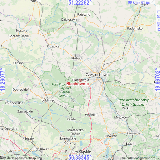
Blachownia GPS coordinates[2]
50° 46' 48.54" North, 18° 57' 50.004" East
| Map corner | latitude | longitude |
|---|---|---|
| Upper-left | 51.22262°, | 18.26077° |
| Center: | 50.78015°, | 18.96389° |
| Lower-right: | 50.33345°, | 19.66702° |
| Map W x H: | 98.9×98.9 km | = 61.5×61.5mi |
| max Lat: | 54.83135° ⇑60.7% North |
| Blachownia: | 50.78015° |
| min Lat: | ⇓39.3% South 49.21328° |
| min Long | Blachownia | max Long |
| 14.20249° | 18.96389° | 24.03723° |
| W 39.4%⇐ | ⇒60.6% E |
Elevation
Elevation of Blachownia is 262 m = 860 ft, and this is 70.6 m = 232 ft above average elevation for this country.
| Max E: |
974 m = 3196 ft | 20.8% |
| Blachownia | 262 m 860 ft | |
| Avg. | 191.4 m = 628 ft | |
Min E: |
-3 m = -10 ft | 79.2% |
See also: Poland elevation on elevation.city.
Geographical zone
Blachownia is located in North temperate zone (between Tropic of Cancer and the Arctic Circle). Distance of this North polar circle is 1755 km =1090.5 mi to North.| Distance of | km | miles | from Blachownia |
|---|---|---|---|
| North Pole | 4360.8 | 2709.7 | to North |
| Arctic Circle | 1755 | 1090.5 | to North |
| Tropic Cancer | 3040.3 | 1889.2 | to South |
| Equator | 5646.2 | 3508.4 | to South |


Nearby cities:
15 places around Blachownia: (largest is in red/bold)
• Biała Dolna
11.6 km =7.2 mi,  36°
36°
• Boronów
12.4 km =7.7 mi,  198°
198°
• Częstochowa
11.4 km =7.1 mi,  80°
80°
• Herby
6.1 km =3.8 mi,  240°
240°
• Huta Stara B
12.8 km =8 mi,  111°
111°
• Kalej
6.4 km =4 mi,  12°
12°
• Kamienica
16.2 km =10.1 mi,  172°
172°
• Kamyk
14.3 km =8.9 mi,  18°
18°
• Konopiska
6.7 km =4.2 mi,  152°
152°
• Kłobuck
13.6 km =8.5 mi,  351°
351°
• Poczesna
14 km =8.7 mi,  121°
121°
• Rudnik Wielki
15.6 km =9.7 mi, 146°
• Starcza
14 km =8.7 mi,  156°
156°
• Truskolasy
13.6 km =8.5 mi,  315°
315°
• Wręczyca Wielka
7.9 km =4.9 mi,  337°
337°
Sources, notices
• [Note1] Compared only with cities in Poland existing in our database
• [Src1] Map data: © OpenStreetMap contributors (CC-BY-SA)
• [Src2] Other city data from geonames.org with taken over terms of usage.
• [Src3] Geographical zone / Annual Mean Temperature by Robert A. Rohde @ Wikipedia
