Częstochowa geodata
Częstochowa (Silesia) is a seat of a third-order administrative division; located in Poland in Europe/Warsaw (GMT+2) time zone. With population of 248,125 people, there are 12 cities with bigger population in this country. Compared to other cities in Poland, 60.3% of cities are located further ↑North; 57.7% of cities are located further →East and 76.8% of cities have lower elevation than Częstochowa. Note1


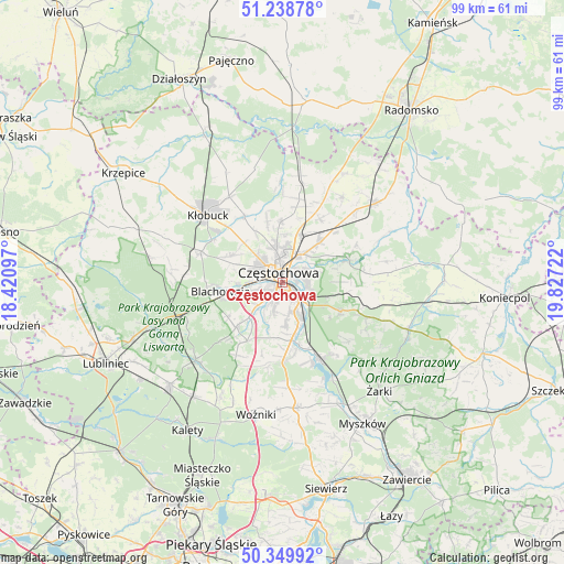
Częstochowa GPS coordinates[2]
50° 47' 47.256" North, 19° 7' 26.724" East
| Map corner | latitude | longitude |
|---|---|---|
| Upper-left | 51.23878°, | 18.42097° |
| Center: | 50.79646°, | 19.12409° |
| Lower-right: | 50.34992°, | 19.82722° |
| Map W x H: | 98.8×98.8 km | = 61.4×61.4mi |
| max Lat: | 54.83135° ⇑60.3% North |
| Częstochowa: | 50.79646° |
| min Lat: | ⇓39.7% South 49.21328° |
| min Long | Częstochowa | max Long |
| 14.20249° | 19.12409° | 24.03723° |
| W 42.3%⇐ | ⇒57.7% E |
Elevation
Elevation of Częstochowa is 253 m = 830 ft, and this is 61.6 m = 202 ft above average elevation for this country.
| Max E: |
974 m = 3196 ft | 23.2% |
| Częstochowa | 253 m 830 ft | |
| Avg. | 191.4 m = 628 ft | |
Min E: |
-3 m = -10 ft | 76.8% |
See also: Częstochowa elevation on elevation.city.
Geographical zone
Częstochowa is located in North temperate zone (between Tropic of Cancer and the Arctic Circle). Distance of this North polar circle is 1753.1 km =1089.3 mi to North.| Distance of | km | miles | from Częstochowa |
|---|---|---|---|
| North Pole | 4359 | 2708.6 | to North |
| Arctic Circle | 1753.1 | 1089.3 | to North |
| Tropic Cancer | 3042.1 | 1890.3 | to South |
| Equator | 5648 | 3509.5 | to South |


Nearby cities:
15 places around Częstochowa: (largest is in red/bold)
• Biała Dolna
8.8 km =5.5 mi,  329°
329°
• Blachownia
11.4 km =7.1 mi,  260°
260°
• Huta Stara B
6.5 km =4 mi,  174°
174°
• Jastrząb
14.6 km =9.1 mi,  163°
163°
• Kalej
10.8 km =6.7 mi,  294°
294°
• Kamienica Polska
14 km =8.7 mi,  180°
180°
• Kamyk
13.5 km =8.4 mi, 330°
• Konopiska
11.3 km =7 mi,  226°
226°
• Kościelec
12.9 km =8 mi,  29°
29°
• Mstów
11.9 km =7.4 mi,  71°
71°
• Olsztyn
11.2 km =7 mi,  116°
116°
• Poczesna
9.1 km =5.7 mi, 175°
• Poraj
14.6 km =9.1 mi,  154°
154°
• Rudniki
12.5 km =7.8 mi,  43°
43°
• Rędziny
9.5 km =5.9 mi, 42°
Sources, notices
• [Note1] Compared only with cities in Poland existing in our database
• [Src1] Map data: © OpenStreetMap contributors (CC-BY-SA)
• [Src2] Other city data from geonames.org with taken over terms of usage.
• [Src3] Geographical zone / Annual Mean Temperature by Robert A. Rohde @ Wikipedia
