Herby geodata
Herby (Silesia) is a populated place; located in Poland in Europe/Warsaw (GMT+2) time zone. With population of 2,421 people, there are 1278 cities with bigger population in this country. Compared to other cities in Poland, 61.4% of cities are located further ↑North; 62.2% of cities are located further →East and 83.7% of cities have lower elevation than Herby. Note1


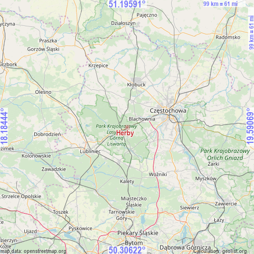
Herby GPS coordinates[2]
50° 45' 11.448" North, 18° 53' 15.216" East
| Map corner | latitude | longitude |
|---|---|---|
| Upper-left | 51.19591°, | 18.18444° |
| Center: | 50.75318°, | 18.88756° |
| Lower-right: | 50.30622°, | 19.59069° |
| Map W x H: | 98.9×98.9 km | = 61.5×61.5mi |
| max Lat: | 54.83135° ⇑61.4% North |
| Herby: | 50.75318° |
| min Lat: | ⇓38.6% South 49.21328° |
| min Long | Herby | max Long |
| 14.20249° | 18.88756° | 24.03723° |
| W 37.8%⇐ | ⇒62.2% E |
Elevation
Elevation of Herby is 284 m = 932 ft, and this is 92.6 m = 304 ft above average elevation for this country.
| Max E: |
974 m = 3196 ft | 16.3% |
| Herby | 284 m 932 ft | |
| Avg. | 191.4 m = 628 ft | |
Min E: |
-3 m = -10 ft | 83.7% |
See also: Poland elevation on elevation.city.
Geographical zone
Herby is located in North temperate zone (between Tropic of Cancer and the Arctic Circle). Distance of this North polar circle is 1757.9 km =1092.3 mi to North.| Distance of | km | miles | from Herby |
|---|---|---|---|
| North Pole | 4363.8 | 2711.5 | to North |
| Arctic Circle | 1757.9 | 1092.3 | to North |
| Tropic Cancer | 3037.3 | 1887.3 | to South |
| Equator | 5643.2 | 3506.5 | to South |


Nearby cities:
15 places around Herby: (largest is in red/bold)
• Blachownia
6.1 km =3.8 mi,  60°
60°
• Boronów
8.8 km =5.5 mi,  171°
171°
• Kalej
11.5 km =7.1 mi,  36°
36°
• Kamienica
15 km =9.3 mi,  150°
150°
• Kochanowice
11.1 km =6.9 mi,  241°
241°
• Konopiska
8.9 km =5.5 mi,  109°
109°
• Koszęcin
13.6 km =8.5 mi,  193°
193°
• Kłobuck
16.8 km =10.4 mi,  11°
11°
• Lubliniec
17.1 km =10.6 mi, 236°
• Psary
16.5 km =10.3 mi,  159°
159°
• Rudnik Wielki
17.2 km =10.7 mi,  125°
125°
• Starcza
14.7 km =9.1 mi, 132°
• Strzebiń
15.2 km =9.4 mi,  177°
177°
• Truskolasy
13.3 km =8.3 mi,  341°
341°
• Wręczyca Wielka
10.6 km =6.6 mi, 12°
Sources, notices
• [Note1] Compared only with cities in Poland existing in our database
• [Src1] Map data: © OpenStreetMap contributors (CC-BY-SA)
• [Src2] Other city data from geonames.org with taken over terms of usage.
• [Src3] Geographical zone / Annual Mean Temperature by Robert A. Rohde @ Wikipedia
