Kalej geodata
Kalej (Silesia) is a populated place; located in Poland in Europe/Warsaw (GMT+2) time zone. With population of 1,668 people, there are 1716 cities with bigger population in this country. Compared to other cities in Poland, 59.5% of cities are located further ↑North; 60.3% of cities are located further →East and 84.4% of cities have lower elevation than Kalej. Note1


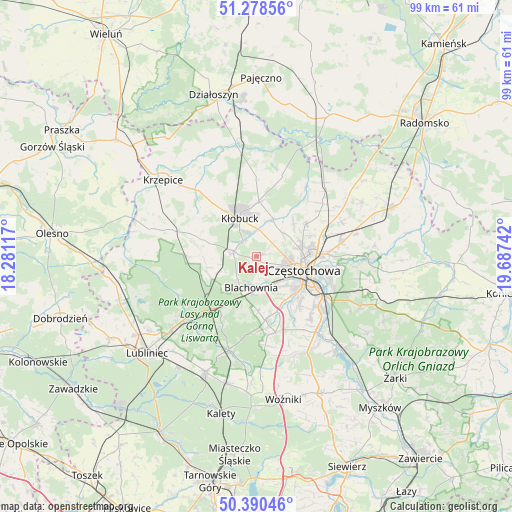
Kalej GPS coordinates[2]
50° 50' 11.832" North, 18° 59' 3.444" East
| Map corner | latitude | longitude |
|---|---|---|
| Upper-left | 51.27856°, | 18.28117° |
| Center: | 50.83662°, | 18.98429° |
| Lower-right: | 50.39046°, | 19.68742° |
| Map W x H: | 98.7×98.7 km | = 61.3×61.3mi |
| max Lat: | 54.83135° ⇑59.5% North |
| Kalej: | 50.83662° |
| min Lat: | ⇓40.5% South 49.21328° |
| min Long | Kalej | max Long |
| 14.20249° | 18.98429° | 24.03723° |
| W 39.7%⇐ | ⇒60.3% E |
Elevation
Elevation of Kalej is 287 m = 942 ft, and this is 95.6 m = 314 ft above average elevation for this country.
| Max E: |
974 m = 3196 ft | 15.6% |
| Kalej | 287 m 942 ft | |
| Avg. | 191.4 m = 628 ft | |
Min E: |
-3 m = -10 ft | 84.4% |
See also: Poland elevation on elevation.city.
Geographical zone
Kalej is located in North temperate zone (between Tropic of Cancer and the Arctic Circle). Distance of this North polar circle is 1748.7 km =1086.6 mi to North.| Distance of | km | miles | from Kalej |
|---|---|---|---|
| North Pole | 4354.6 | 2705.8 | to North |
| Arctic Circle | 1748.7 | 1086.6 | to North |
| Tropic Cancer | 3046.6 | 1893.1 | to South |
| Equator | 5652.5 | 3512.3 | to South |


Nearby cities:
15 places around Kalej: (largest is in red/bold)
• Biała Dolna
6.3 km =3.9 mi,  60°
60°
• Blachownia
6.4 km =4 mi,  192°
192°
• Częstochowa
10.8 km =6.7 mi,  114°
114°
• Herby
11.5 km =7.1 mi,  216°
216°
• Huta Stara B
15.2 km =9.4 mi,  136°
136°
• Kamyk
7.9 km =4.9 mi,  23°
23°
• Konopiska
12.3 km =7.6 mi,  172°
172°
• Kłobuck
7.9 km =4.9 mi,  334°
334°
• Miedzno
14.8 km =9.2 mi,  359°
359°
• Ostrowy nad Okszą
16.5 km =10.3 mi, 17°
• Panki
17.1 km =10.6 mi,  287°
287°
• Rędziny
16.5 km =10.3 mi,  81°
81°
• Truskolasy
11.5 km =7.1 mi, 286°
• Wręczyca Wielka
4.6 km =2.9 mi,  283°
283°
• Łobodno
10.5 km =6.5 mi,  2°
2°
Sources, notices
• [Note1] Compared only with cities in Poland existing in our database
• [Src1] Map data: © OpenStreetMap contributors (CC-BY-SA)
• [Src2] Other city data from geonames.org with taken over terms of usage.
• [Src3] Geographical zone / Annual Mean Temperature by Robert A. Rohde @ Wikipedia
