Poczesna geodata
Poczesna (Silesia) is a populated place; located in Poland in Europe/Warsaw (GMT+2) time zone. With population of 786 people, there are 2888 cities with bigger population in this country. Compared to other cities in Poland, 62.4% of cities are located further ↑North; 57.4% of cities are located further →East and 81.4% of cities have lower elevation than Poczesna. Note1


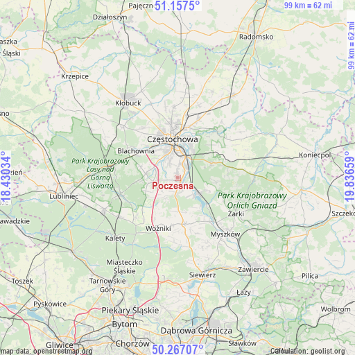
Poczesna GPS coordinates[2]
50° 42' 51.84" North, 19° 8' 0.456" East
| Map corner | latitude | longitude |
|---|---|---|
| Upper-left | 51.1575°, | 18.43034° |
| Center: | 50.7144°, | 19.13346° |
| Lower-right: | 50.26707°, | 19.83659° |
| Map W x H: | 99×99 km | = 61.5×61.5mi |
| max Lat: | 54.83135° ⇑62.4% North |
| Poczesna: | 50.7144° |
| min Lat: | ⇓37.6% South 49.21328° |
| min Long | Poczesna | max Long |
| 14.20249° | 19.13346° | 24.03723° |
| W 42.6%⇐ | ⇒57.4% E |
Elevation
Elevation of Poczesna is 273 m = 896 ft, and this is 81.6 m = 268 ft above average elevation for this country.
| Max E: |
974 m = 3196 ft | 18.6% |
| Poczesna | 273 m 896 ft | |
| Avg. | 191.4 m = 628 ft | |
Min E: |
-3 m = -10 ft | 81.4% |
See also: Poland elevation on elevation.city.
Geographical zone
Poczesna is located in North temperate zone (between Tropic of Cancer and the Arctic Circle). Distance of this North polar circle is 1762.3 km =1095 mi to North.| Distance of | km | miles | from Poczesna |
|---|---|---|---|
| North Pole | 4368.1 | 2714.2 | to North |
| Arctic Circle | 1762.3 | 1095 | to North |
| Tropic Cancer | 3033 | 1884.6 | to South |
| Equator | 5638.9 | 3503.8 | to South |


Nearby cities:
15 places around Poczesna: (largest is in red/bold)
• Blachownia
14 km =8.7 mi,  301°
301°
• Choroń
9.7 km =6 mi,  112°
112°
• Częstochowa
9.1 km =5.7 mi,  355°
355°
• Gniazdów
13.2 km =8.2 mi,  186°
186°
• Huta Stara B
2.6 km =1.6 mi, 359°
• Jastrząb
6 km =3.7 mi,  145°
145°
• Kamienica
13.2 km =8.2 mi,  228°
228°
• Kamienica Polska
4.9 km =3 mi, 188°
• Konopiska
9 km =5.6 mi,  278°
278°
• Koziegłowy
12.9 km =8 mi,  170°
170°
• Olsztyn
10.3 km =6.4 mi,  66°
66°
• Poraj
7 km =4.3 mi,  125°
125°
• Rudnik Wielki
6.6 km =4.1 mi,  210°
210°
• Siedlec Duży
9.4 km =5.8 mi,  180°
180°
• Starcza
8.5 km =5.3 mi, 229°
Sources, notices
• [Note1] Compared only with cities in Poland existing in our database
• [Src1] Map data: © OpenStreetMap contributors (CC-BY-SA)
• [Src2] Other city data from geonames.org with taken over terms of usage.
• [Src3] Geographical zone / Annual Mean Temperature by Robert A. Rohde @ Wikipedia
