Kozłów geodata
Kozłów (Silesia) is a populated place; located in Poland in Europe/Warsaw (GMT+2) time zone. With population of 977 people, there are 2542 cities with bigger population in this country. Compared to other cities in Poland, 71.9% of cities are located further ↑North; 67.2% of cities are located further →East and 71.4% of cities have lower elevation than Kozłów. Note1


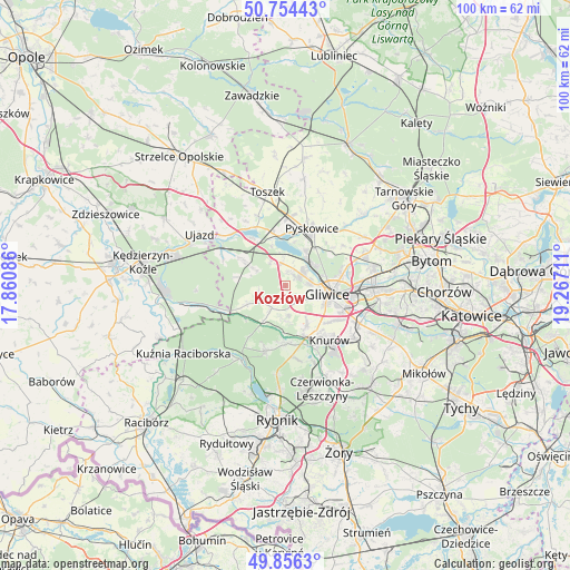
Kozłów GPS coordinates[2]
50° 18' 26.964" North, 18° 33' 50.328" East
| Map corner | latitude | longitude |
|---|---|---|
| Upper-left | 50.75443°, | 17.86086° |
| Center: | 50.30749°, | 18.56398° |
| Lower-right: | 49.8563°, | 19.26711° |
| Map W x H: | 99.9×99.9 km | = 62.1×62.1mi |
| max Lat: | 54.83135° ⇑71.9% North |
| Kozłów: | 50.30749° |
| min Lat: | ⇓28.1% South 49.21328° |
| min Long | Kozłów | max Long |
| 14.20249° | 18.56398° | 24.03723° |
| W 32.8%⇐ | ⇒67.2% E |
Elevation
Elevation of Kozłów is 233 m = 764 ft, and this is 41.6 m = 136 ft above average elevation for this country.
| Max E: |
974 m = 3196 ft | 28.6% |
| Kozłów | 233 m 764 ft | |
| Avg. | 191.4 m = 628 ft | |
Min E: |
-3 m = -10 ft | 71.4% |
See also: Poland elevation on elevation.city.
Geographical zone
Kozłów is located in North temperate zone (between Tropic of Cancer and the Arctic Circle). Distance of this North polar circle is 1807.5 km =1123.1 mi to North.| Distance of | km | miles | from Kozłów |
|---|---|---|---|
| North Pole | 4413.4 | 2742.4 | to North |
| Arctic Circle | 1807.5 | 1123.1 | to North |
| Tropic Cancer | 2987.7 | 1856.5 | to South |
| Equator | 5593.7 | 3475.8 | to South |


Nearby cities:
15 places around Kozłów: (largest is in red/bold)
• Gierałtowice
15.2 km =9.4 mi,  127°
127°
• Gliwice
8.1 km =5 mi,  97°
97°
• Kleszczów
5.2 km =3.2 mi,  329°
329°
• Knurów
11.5 km =7.1 mi,  147°
147°
• Pilchowice
10.1 km =6.3 mi,  181°
181°
• Przyszowice
14.5 km =9 mi,  116°
116°
• Pyskowice
11.4 km =7.1 mi,  25°
25°
• Rudy
15.2 km =9.4 mi,  211°
211°
• Rudziniec
12.1 km =7.5 mi,  294°
294°
• Sośnicowice
4.6 km =2.9 mi, 211°
• Toszek
16.6 km =10.3 mi,  349°
349°
• Wieszowa
16.3 km =10.1 mi,  58°
58°
• Wilcza
13.4 km =8.3 mi,  169°
169°
• Zabrze
15.9 km =9.9 mi,  82°
82°
• Żernica
7.6 km =4.7 mi, 151°
Sources, notices
• [Note1] Compared only with cities in Poland existing in our database
• [Src1] Map data: © OpenStreetMap contributors (CC-BY-SA)
• [Src2] Other city data from geonames.org with taken over terms of usage.
• [Src3] Geographical zone / Annual Mean Temperature by Robert A. Rohde @ Wikipedia
