Babimost geodata
Babimost (Lubusz) is a seat of a third-order administrative division; located in Poland in Europe/Warsaw (GMT+2) time zone. With population of 4,182 people, there are 784 cities with bigger population in this country. Compared to other cities in Poland, 69.2% of cities are located further ↓South; 93.4% of cities are located further →East and 93.4% of cities have higher elevation than Babimost. Note1


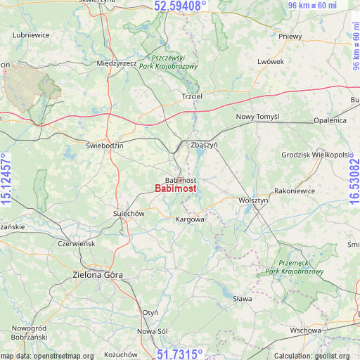
Babimost GPS coordinates[2]
52° 9' 53.568" North, 15° 49' 39.684" East
| Map corner | latitude | longitude |
|---|---|---|
| Upper-left | 52.59408°, | 15.12457° |
| Center: | 52.16488°, | 15.82769° |
| Lower-right: | 51.7315°, | 16.53082° |
| Map W x H: | 95.9×95.9 km | = 59.6×59.6mi |
| max Lat: | 54.83135° ⇑30.8% North |
| Babimost: | 52.16488° |
| min Lat: | ⇓69.2% South 49.21328° |
| min Long | Babimost | max Long |
| 14.20249° | 15.82769° | 24.03723° |
| W 6.6%⇐ | ⇒93.4% E |
Elevation
Elevation of Babimost is 57 m = 187 ft, and this is 134.4 m = 441 ft below average elevation for this country.
| Max E: |
974 m = 3196 ft | 93.4% |
| Avg. | 191.4 m = 628 ft | |
| Babimost | 57 m = 187 ft | |
Min E: |
-3 m = -10 ft | 6.6% |
See also: Poland elevation on elevation.city.
Geographical zone
Babimost is located in North temperate zone (between Tropic of Cancer and the Arctic Circle). Distance of this North polar circle is 1601 km =994.8 mi to North.| Distance of | km | miles | from Babimost |
|---|---|---|---|
| North Pole | 4206.9 | 2614 | to North |
| Arctic Circle | 1601 | 994.8 | to North |
| Tropic Cancer | 3194.3 | 1984.8 | to South |
| Equator | 5800.2 | 3604.1 | to South |


Nearby cities:
15 places around Babimost: (largest is in red/bold)
• Brójce
19.9 km =12.4 mi,  328°
328°
• Cigacice
20.5 km =12.7 mi,  225°
225°
• Kargowa
10.6 km =6.6 mi,  167°
167°
• Kije
20.9 km =13 mi,  249°
249°
• Klenica
19.4 km =12.1 mi,  188°
188°
• Siedlec
12.3 km =7.6 mi,  104°
104°
• Sulechów
16.5 km =10.3 mi,  236°
236°
• Swarzynice
19 km =11.8 mi,  195°
195°
• Szczaniec
15.2 km =9.4 mi,  319°
319°
• Trzciel
22.5 km =14 mi,  7°
7°
• Trzebiechów
17.2 km =10.7 mi, 201°
• Wolsztyn
20.5 km =12.7 mi,  105°
105°
• Zbąszynek
8.7 km =5.4 mi,  355°
355°
• Zbąszyń
11.6 km =7.2 mi,  34°
34°
• Świebodzin
22 km =13.7 mi,  294°
294°
Sources, notices
• [Note1] Compared only with cities in Poland existing in our database
• [Src1] Map data: © OpenStreetMap contributors (CC-BY-SA)
• [Src2] Other city data from geonames.org with taken over terms of usage.
• [Src3] Geographical zone / Annual Mean Temperature by Robert A. Rohde @ Wikipedia
