Konotop geodata
Konotop (Lubusz) is a populated place; located in Poland in Europe/Warsaw (GMT+2) time zone. With population of 1,400 people, there are 1959 cities with bigger population in this country. Compared to other cities in Poland, 64.4% of cities are located further ↓South; 93% of cities are located further →East and 93.1% of cities have higher elevation than Konotop. Note1


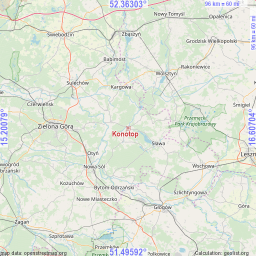
Konotop GPS coordinates[2]
51° 55' 53.652" North, 15° 54' 14.076" East
| Map corner | latitude | longitude |
|---|---|---|
| Upper-left | 52.36303°, | 15.20079° |
| Center: | 51.93157°, | 15.90391° |
| Lower-right: | 51.49592°, | 16.60704° |
| Map W x H: | 96.4×96.4 km | = 59.9×59.9mi |
| max Lat: | 54.83135° ⇑35.6% North |
| Konotop: | 51.93157° |
| min Lat: | ⇓64.4% South 49.21328° |
| min Long | Konotop | max Long |
| 14.20249° | 15.90391° | 24.03723° |
| W 7%⇐ | ⇒93% E |
Elevation
Elevation of Konotop is 59 m = 194 ft, and this is 132.4 m = 434 ft below average elevation for this country.
| Max E: |
974 m = 3196 ft | 93.1% |
| Avg. | 191.4 m = 628 ft | |
| Konotop | 59 m = 194 ft | |
Min E: |
-3 m = -10 ft | 6.9% |
See also: Poland elevation on elevation.city.
Geographical zone
Konotop is located in North temperate zone (between Tropic of Cancer and the Arctic Circle). Distance of this North polar circle is 1626.9 km =1010.9 mi to North.| Distance of | km | miles | from Konotop |
|---|---|---|---|
| North Pole | 4232.8 | 2630.1 | to North |
| Arctic Circle | 1626.9 | 1010.9 | to North |
| Tropic Cancer | 3168.3 | 1968.7 | to South |
| Equator | 5774.2 | 3587.9 | to South |


Nearby cities:
15 places around Konotop: (largest is in red/bold)
• Bielawy
18.2 km =11.3 mi,  172°
172°
• Bobrowniki
13.9 km =8.6 mi,  237°
237°
• Bojadła
6.8 km =4.2 mi,  290°
290°
• Kargowa
15.8 km =9.8 mi,  349°
349°
• Klenica
10.6 km =6.6 mi,  309°
309°
• Kolsko
5.1 km =3.2 mi,  49°
49°
• Lubięcin
4.9 km =3 mi,  202°
202°
• Nowa Sól
19.2 km =11.9 mi,  221°
221°
• Otyń
16.2 km =10.1 mi,  234°
234°
• Przyborów
17.3 km =10.7 mi,  212°
212°
• Siedlisko
19.1 km =11.9 mi, 198°
• Swarzynice
13 km =8.1 mi, 306°
• Sława
13.1 km =8.1 mi,  118°
118°
• Trzebiechów
15.2 km =9.4 mi, 310°
• Zabór
13 km =8.1 mi,  280°
280°
Sources, notices
• [Note1] Compared only with cities in Poland existing in our database
• [Src1] Map data: © OpenStreetMap contributors (CC-BY-SA)
• [Src2] Other city data from geonames.org with taken over terms of usage.
• [Src3] Geographical zone / Annual Mean Temperature by Robert A. Rohde @ Wikipedia
