Kazimierz Biskupi geodata
Kazimierz Biskupi (Greater Poland) is a seat of a third-order administrative division; located in Poland in Europe/Warsaw (GMT+2) time zone. With population of 4,280 people, there are 766 cities with bigger population in this country. Compared to other cities in Poland, 72.8% of cities are located further ↓South; 73.1% of cities are located further →East and 82.7% of cities have higher elevation than Kazimierz Biskupi. Note1
Administrative division(s):
- Level 1: Greater Poland
- Level 2: Powiat koniński
- Level 3: Kazimierz Biskupi


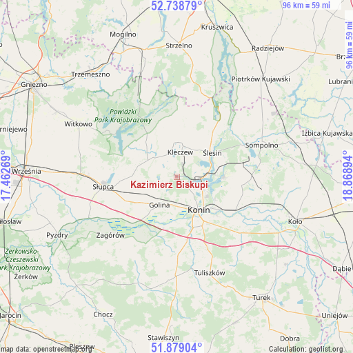
Kazimierz Biskupi GPS coordinates[2]
52° 18' 39.6" North, 18° 9' 56.916" East
| Map corner | latitude | longitude |
|---|---|---|
| Upper-left | 52.73879°, | 17.46269° |
| Center: | 52.311°, | 18.16581° |
| Lower-right: | 51.87904°, | 18.86894° |
| Map W x H: | 95.6×95.6 km | = 59.4×59.4mi |
| max Lat: | 54.83135° ⇑27.2% North |
| Kazimierz Biskupi: | 52.311° |
| min Lat: | ⇓72.8% South 49.21328° |
| min Long | Kazimierz Bisku | max Long |
| 14.20249° | 18.16581° | 24.03723° |
| W 26.9%⇐ | ⇒73.1% E |
Elevation
Elevation of Kazimierz Biskupi is 94 m = 308 ft, and this is 97.4 m = 320 ft below average elevation for this country.
| Max E: |
974 m = 3196 ft | 82.7% |
| Avg. | 191.4 m = 628 ft | |
| Kazimierz Biskupi | 94 m = 308 ft | |
Min E: |
-3 m = -10 ft | 17.3% |
See also: Poland elevation on elevation.city.
Geographical zone
Kazimierz Biskupi is located in North temperate zone (between Tropic of Cancer and the Arctic Circle). Distance of this North polar circle is 1584.7 km =984.7 mi to North.| Distance of | km | miles | from Kazimierz Biskupi |
|---|---|---|---|
| North Pole | 4190.6 | 2603.9 | to North |
| Arctic Circle | 1584.7 | 984.7 | to North |
| Tropic Cancer | 3210.5 | 1994.9 | to South |
| Equator | 5816.4 | 3614.1 | to South |


Nearby cities:
15 places around Kazimierz Biskupi: (largest is in red/bold)
• Golina
9 km =5.6 mi,  213°
213°
• Kleczew
6.7 km =4.2 mi,  6°
6°
• Konin
11.3 km =7 mi,  149°
149°
• Kramsk
18.3 km =11.4 mi,  106°
106°
• Licheń Stary
12.9 km =8 mi,  89°
89°
• Lądek
19.6 km =12.2 mi,  234°
234°
• Ostrowite
11.4 km =7.1 mi,  313°
313°
• Police
21.5 km =13.4 mi,  73°
73°
• Powidz
20.3 km =12.6 mi,  304°
304°
• Rzgów Pierwszy
19.4 km =12.1 mi,  203°
203°
• Stare Miasto
15 km =9.3 mi,  167°
167°
• Słupca
20.2 km =12.6 mi,  262°
262°
• Wilczogóra
18.1 km =11.2 mi,  0°
0°
• Wilczyn
19.7 km =12.2 mi,  359°
359°
• Ślesin
11.6 km =7.2 mi,  55°
55°
Sources, notices
• [Note1] Compared only with cities in Poland existing in our database
• [Src1] Map data: © OpenStreetMap contributors (CC-BY-SA)
• [Src2] Other city data from geonames.org with taken over terms of usage.
• [Src3] Geographical zone / Annual Mean Temperature by Robert A. Rohde @ Wikipedia
