Powidz geodata
Powidz (Greater Poland) is a seat of a third-order administrative division; located in Poland in Europe/Warsaw (GMT+2) time zone. With population of 1,000 people, there are 2459 cities with bigger population in this country. Compared to other cities in Poland, 75% of cities are located further ↓South; 76.1% of cities are located further →East and 76.9% of cities have higher elevation than Powidz. Note1


Powidz GPS coordinates[2]
52° 24' 49.032" North, 17° 55' 9.336" East
| Map corner | latitude | longitude |
|---|---|---|
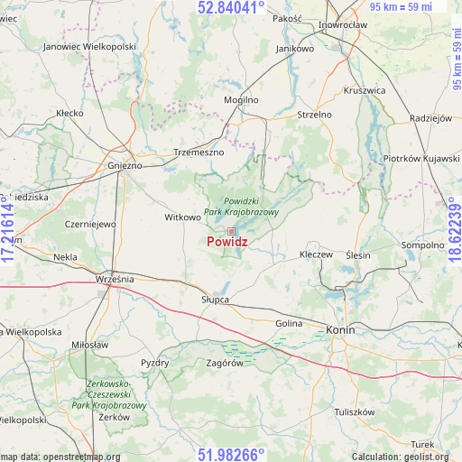
| Upper-left | 52.84041°, | 17.21614° |
| Center: | 52.41362°, | 17.91926° |
| Lower-right: | 51.98266°, | 18.62239° |
| Map W x H: | 95.4×95.4 km | = 59.3×59.3mi |
| max Lat: | 54.83135° ⇑25% North |
| Powidz: | 52.41362° |
| min Lat: | ⇓75% South 49.21328° |
| min Long | Powidz | max Long |
| 14.20249° | 17.91926° | 24.03723° |
| W 23.9%⇐ | ⇒76.1% E |
Elevation
Elevation of Powidz is 106 m = 348 ft, and this is 85.4 m = 280 ft below average elevation for this country.
| Max E: |
974 m = 3196 ft | 76.9% |
| Avg. | 191.4 m = 628 ft | |
| Powidz | 106 m = 348 ft | |
Min E: |
-3 m = -10 ft | 23.1% |
See also: Poland elevation on elevation.city.
Geographical zone
Powidz is located in North temperate zone (between Tropic of Cancer and the Arctic Circle). Distance of this North polar circle is 1573.3 km =977.6 mi to North.| Distance of | km | miles | from Powidz |
|---|---|---|---|
| North Pole | 4179.2 | 2596.8 | to North |
| Arctic Circle | 1573.3 | 977.6 | to North |
| Tropic Cancer | 3221.9 | 2002 | to South |
| Equator | 5827.8 | 3621.2 | to South |


Nearby cities:
15 places around Powidz: (largest is in red/bold)
• Golina
22.3 km =13.9 mi,  148°
148°
• Kazimierz Biskupi
20.3 km =12.6 mi,  124°
124°
• Kleczew
18.1 km =11.2 mi,  105°
105°
• Lądek
22.7 km =14.1 mi,  178°
178°
• Niechanowo
17.3 km =10.7 mi,  289°
289°
• Orchowo
12.5 km =7.8 mi,  31°
31°
• Ostrowite
9.2 km =5.7 mi, 112°
• Sokolniki
23 km =14.3 mi,  218°
218°
• Strzałkowo
13.7 km =8.5 mi,  210°
210°
• Słupca
14.4 km =8.9 mi,  192°
192°
• Trzemeszno
17.7 km =11 mi,  338°
338°
• Wilczogóra
18.1 km =11.2 mi,  68°
68°
• Wilczyn
18.4 km =11.4 mi,  63°
63°
• Witkowo
10.4 km =6.5 mi, 286°
• Września
26 km =16.2 mi,  247°
247°
Sources, notices
• [Note1] Compared only with cities in Poland existing in our database
• [Src1] Map data: © OpenStreetMap contributors (CC-BY-SA)
• [Src2] Other city data from geonames.org with taken over terms of usage.
• [Src3] Geographical zone / Annual Mean Temperature by Robert A. Rohde @ Wikipedia
