Konin geodata
Konin (Greater Poland) is a populated place; located in Poland in Europe/Warsaw (GMT+2) time zone. With population of 81,258 people, there are 56 cities with bigger population in this country. Compared to other cities in Poland, 70.7% of cities are located further ↓South; 71.9% of cities are located further →East and 87.5% of cities have higher elevation than Konin. Note1


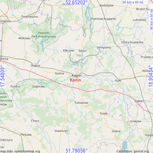
Konin GPS coordinates[2]
52° 13' 24.168" North, 18° 15' 4.356" East
| Map corner | latitude | longitude |
|---|---|---|
| Upper-left | 52.65202°, | 17.54809° |
| Center: | 52.22338°, | 18.25121° |
| Lower-right: | 51.79056°, | 18.95434° |
| Map W x H: | 95.8×95.8 km | = 59.5×59.5mi |
| max Lat: | 54.83135° ⇑29.3% North |
| Konin: | 52.22338° |
| min Lat: | ⇓70.7% South 49.21328° |
| min Long | Konin | max Long |
| 14.20249° | 18.25121° | 24.03723° |
| W 28.1%⇐ | ⇒71.9% E |
Elevation
Elevation of Konin is 83 m = 272 ft, and this is 108.4 m = 356 ft below average elevation for this country.
| Max E: |
974 m = 3196 ft | 87.5% |
| Avg. | 191.4 m = 628 ft | |
| Konin | 83 m = 272 ft | |
Min E: |
-3 m = -10 ft | 12.5% |
See also: Konin elevation on elevation.city.
Geographical zone
Konin is located in North temperate zone (between Tropic of Cancer and the Arctic Circle). Distance of this North polar circle is 1594.5 km =990.8 mi to North.| Distance of | km | miles | from Konin |
|---|---|---|---|
| North Pole | 4200.4 | 2610 | to North |
| Arctic Circle | 1594.5 | 990.8 | to North |
| Tropic Cancer | 3200.8 | 1988.9 | to South |
| Equator | 5806.7 | 3608.1 | to South |


Nearby cities:
15 places around Konin: (largest is in red/bold)
• Golina
11 km =6.8 mi,  281°
281°
• Kazimierz Biskupi
11.3 km =7 mi,  329°
329°
• Kleczew
17.1 km =10.6 mi,  342°
342°
• Kramsk
12.6 km =7.8 mi,  68°
68°
• Krzymów
12.8 km =8 mi,  107°
107°
• Licheń Stary
12.2 km =7.6 mi,  35°
35°
• Paprotnia
12.8 km =8 mi,  115°
115°
• Russocice
19.9 km =12.4 mi,  128°
128°
• Rychwał
17.9 km =11.1 mi,  199°
199°
• Rzgów Pierwszy
15.9 km =9.9 mi,  239°
239°
• Stare Miasto
5.4 km =3.4 mi,  206°
206°
• Tarnowa
16.5 km =10.3 mi,  149°
149°
• Tuliszków
16.6 km =10.3 mi,  169°
169°
• Władysławów
20.4 km =12.7 mi, 131°
• Ślesin
16.8 km =10.4 mi,  12°
12°
Sources, notices
• [Note1] Compared only with cities in Poland existing in our database
• [Src1] Map data: © OpenStreetMap contributors (CC-BY-SA)
• [Src2] Other city data from geonames.org with taken over terms of usage.
• [Src3] Geographical zone / Annual Mean Temperature by Robert A. Rohde @ Wikipedia
