Stare Miasto geodata
Stare Miasto (Greater Poland) is a seat of a third-order administrative division; located in Poland in Europe/Warsaw (GMT+2) time zone. With population of 1,500 people, there are 1837 cities with bigger population in this country. Compared to other cities in Poland, 69.6% of cities are located further ↓South; 72.4% of cities are located further →East and 84.6% of cities have higher elevation than Stare Miasto. Note1


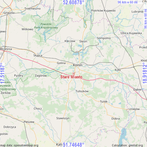
Stare Miasto GPS coordinates[2]
52° 10' 46.992" North, 18° 12' 53.964" East
| Map corner | latitude | longitude |
|---|---|---|
| Upper-left | 52.60878°, | 17.51187° |
| Center: | 52.17972°, | 18.21499° |
| Lower-right: | 51.74648°, | 18.91812° |
| Map W x H: | 95.9×95.9 km | = 59.6×59.6mi |
| max Lat: | 54.83135° ⇑30.4% North |
| Stare Miasto: | 52.17972° |
| min Lat: | ⇓69.6% South 49.21328° |
| min Long | Stare Miasto | max Long |
| 14.20249° | 18.21499° | 24.03723° |
| W 27.6%⇐ | ⇒72.4% E |
Elevation
Elevation of Stare Miasto is 90 m = 295 ft, and this is 101.4 m = 333 ft below average elevation for this country.
| Max E: |
974 m = 3196 ft | 84.6% |
| Avg. | 191.4 m = 628 ft | |
| Stare Miasto | 90 m = 295 ft | |
Min E: |
-3 m = -10 ft | 15.4% |
See also: Poland elevation on elevation.city.
Geographical zone
Stare Miasto is located in North temperate zone (between Tropic of Cancer and the Arctic Circle). Distance of this North polar circle is 1599.3 km =993.8 mi to North.| Distance of | km | miles | from Stare Miasto |
|---|---|---|---|
| North Pole | 4205.2 | 2613 | to North |
| Arctic Circle | 1599.3 | 993.8 | to North |
| Tropic Cancer | 3195.9 | 1985.8 | to South |
| Equator | 5801.8 | 3605.1 | to South |


Nearby cities:
15 places around Stare Miasto: (largest is in red/bold)
• Golina
10.9 km =6.8 mi,  310°
310°
• Grodziec
18.9 km =11.7 mi,  214°
214°
• Kazimierz Biskupi
15 km =9.3 mi,  347°
347°
• Konin
5.4 km =3.4 mi,  26°
26°
• Kramsk
17.1 km =10.6 mi,  56°
56°
• Krzymów
14.8 km =9.2 mi,  85°
85°
• Licheń Stary
17.6 km =10.9 mi, 32°
• Lądek
19.7 km =12.2 mi,  279°
279°
• Paprotnia
14 km =8.7 mi, 92°
• Russocice
19.6 km =12.2 mi,  112°
112°
• Rychwał
12.5 km =7.8 mi,  195°
195°
• Rzgów Pierwszy
11.7 km =7.3 mi,  254°
254°
• Tarnowa
14.3 km =8.9 mi,  131°
131°
• Tuliszków
12.7 km =7.9 mi,  154°
154°
• Władysławów
19.8 km =12.3 mi,  115°
115°
Sources, notices
• [Note1] Compared only with cities in Poland existing in our database
• [Src1] Map data: © OpenStreetMap contributors (CC-BY-SA)
• [Src2] Other city data from geonames.org with taken over terms of usage.
• [Src3] Geographical zone / Annual Mean Temperature by Robert A. Rohde @ Wikipedia
