Słupca geodata
Słupca (Greater Poland) is a seat of a second-order administrative division; located in Poland in Europe/Warsaw (GMT+2) time zone. With population of 14,476 people, there are 345 cities with bigger population in this country. Compared to other cities in Poland, 72.2% of cities are located further ↓South; 76.4% of cities are located further →East and 82.7% of cities have higher elevation than Słupca. Note1


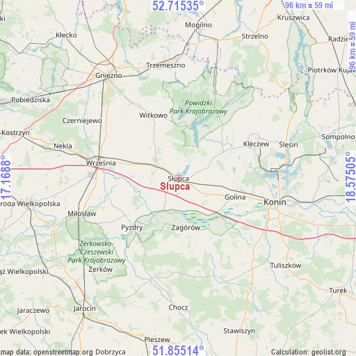
Słupca GPS coordinates[2]
52° 17' 14.388" North, 17° 52' 18.912" East
| Map corner | latitude | longitude |
|---|---|---|
| Upper-left | 52.71535°, | 17.1688° |
| Center: | 52.28733°, | 17.87192° |
| Lower-right: | 51.85514°, | 18.57505° |
| Map W x H: | 95.6×95.6 km | = 59.4×59.4mi |
| max Lat: | 54.83135° ⇑27.8% North |
| Słupca: | 52.28733° |
| min Lat: | ⇓72.2% South 49.21328° |
| min Long | Słupca | max Long |
| 14.20249° | 17.87192° | 24.03723° |
| W 23.6%⇐ | ⇒76.4% E |
Elevation
Elevation of Słupca is 94 m = 308 ft, and this is 97.4 m = 320 ft below average elevation for this country.
| Max E: |
974 m = 3196 ft | 82.7% |
| Avg. | 191.4 m = 628 ft | |
| Słupca | 94 m = 308 ft | |
Min E: |
-3 m = -10 ft | 17.3% |
See also: Poland elevation on elevation.city.
Geographical zone
Słupca is located in North temperate zone (between Tropic of Cancer and the Arctic Circle). Distance of this North polar circle is 1587.4 km =986.4 mi to North.| Distance of | km | miles | from Słupca |
|---|---|---|---|
| North Pole | 4193.3 | 2605.6 | to North |
| Arctic Circle | 1587.4 | 986.4 | to North |
| Tropic Cancer | 3207.9 | 1993.3 | to South |
| Equator | 5813.8 | 3612.5 | to South |


Nearby cities:
15 places around Słupca: (largest is in red/bold)
• Golina
15.8 km =9.8 mi,  108°
108°
• Grabowo Królewskie
17.8 km =11.1 mi,  253°
253°
• Kazimierz Biskupi
20.2 km =12.6 mi,  82°
82°
• Kleczew
22.7 km =14.1 mi,  65°
65°
• Kołaczkowo
18.6 km =11.6 mi, 245°
• Lądek
9.5 km =5.9 mi,  155°
155°
• Ostrowite
15.8 km =9.8 mi,  48°
48°
• Powidz
14.4 km =8.9 mi,  12°
12°
• Pyzdry
17.9 km =11.1 mi,  223°
223°
• Rzgów Pierwszy
19.4 km =12.1 mi,  141°
141°
• Sokolniki
11.9 km =7.4 mi, 250°
• Strzałkowo
4.3 km =2.7 mi,  300°
300°
• Witkowo
18.2 km =11.3 mi,  338°
338°
• Września
21.3 km =13.2 mi,  281°
281°
• Zagórów
13.3 km =8.3 mi,  173°
173°
Sources, notices
• [Note1] Compared only with cities in Poland existing in our database
• [Src1] Map data: © OpenStreetMap contributors (CC-BY-SA)
• [Src2] Other city data from geonames.org with taken over terms of usage.
• [Src3] Geographical zone / Annual Mean Temperature by Robert A. Rohde @ Wikipedia
