Lądek geodata
Lądek (Greater Poland) is a seat of a third-order administrative division; located in Poland in Europe/Warsaw (GMT+2) time zone. With population of 790 people, there are 2877 cities with bigger population in this country. Compared to other cities in Poland, 70.4% of cities are located further ↓South; 76% of cities are located further →East and 81.8% of cities have higher elevation than Lądek. Note1


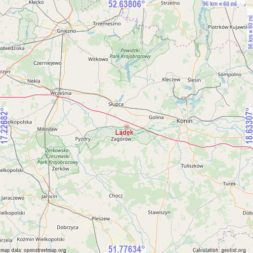
Lądek GPS coordinates[2]
52° 12' 33.444" North, 17° 55' 47.784" East
| Map corner | latitude | longitude |
|---|---|---|
| Upper-left | 52.63806°, | 17.22682° |
| Center: | 52.20929°, | 17.92994° |
| Lower-right: | 51.77634°, | 18.63307° |
| Map W x H: | 95.8×95.8 km | = 59.5×59.5mi |
| max Lat: | 54.83135° ⇑29.6% North |
| Lądek: | 52.20929° |
| min Lat: | ⇓70.4% South 49.21328° |
| min Long | Lądek | max Long |
| 14.20249° | 17.92994° | 24.03723° |
| W 24%⇐ | ⇒76% E |
Elevation
Elevation of Lądek is 96 m = 315 ft, and this is 95.4 m = 313 ft below average elevation for this country.
| Max E: |
974 m = 3196 ft | 81.8% |
| Avg. | 191.4 m = 628 ft | |
| Lądek | 96 m = 315 ft | |
Min E: |
-3 m = -10 ft | 18.2% |
See also: Poland elevation on elevation.city.
Geographical zone
Lądek is located in North temperate zone (between Tropic of Cancer and the Arctic Circle). Distance of this North polar circle is 1596 km =991.7 mi to North.| Distance of | km | miles | from Lądek |
|---|---|---|---|
| North Pole | 4201.9 | 2610.9 | to North |
| Arctic Circle | 1596 | 991.7 | to North |
| Tropic Cancer | 3199.2 | 1987.9 | to South |
| Equator | 5805.1 | 3607.1 | to South |


Nearby cities:
15 places around Lądek: (largest is in red/bold)
• Golina
11.7 km =7.3 mi,  71°
71°
• Grabowo Królewskie
21.4 km =13.3 mi,  279°
279°
• Grodziec
20.9 km =13 mi,  154°
154°
• Kazimierz Biskupi
19.6 km =12.2 mi,  54°
54°
• Kołaczkowo
20.9 km =13 mi,  272°
272°
• Lisewo
21.3 km =13.2 mi,  228°
228°
• Ostrowite
20.7 km =12.9 mi,  22°
22°
• Pyzdry
16.9 km =10.5 mi,  255°
255°
• Rzgów Pierwszy
10.4 km =6.5 mi,  128°
128°
• Sokolniki
15.9 km =9.9 mi,  287°
287°
• Stare Miasto
19.7 km =12.2 mi,  99°
99°
• Strzałkowo
13.3 km =8.3 mi,  324°
324°
• Słupca
9.5 km =5.9 mi,  335°
335°
• Tomice
20.6 km =12.8 mi,  219°
219°
• Zagórów
5.1 km =3.2 mi,  207°
207°
Sources, notices
• [Note1] Compared only with cities in Poland existing in our database
• [Src1] Map data: © OpenStreetMap contributors (CC-BY-SA)
• [Src2] Other city data from geonames.org with taken over terms of usage.
• [Src3] Geographical zone / Annual Mean Temperature by Robert A. Rohde @ Wikipedia
