Sobótka geodata
Sobótka (Lower Silesia) is a seat of a third-order administrative division; located in Poland in Europe/Warsaw (GMT+2) time zone. With population of 6,906 people, there are 545 cities with bigger population in this country. Compared to other cities in Poland, 57.7% of cities are located further ↑North; 87.6% of cities are located further →East and 54.4% of cities have lower elevation than Sobótka. Note1


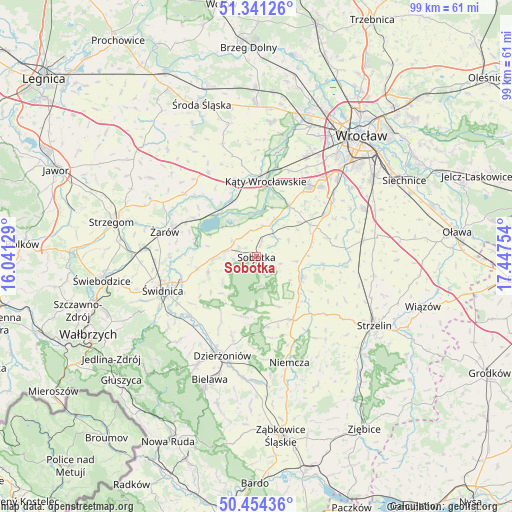
Sobótka GPS coordinates[2]
50° 53' 59.712" North, 16° 44' 39.876" East
| Map corner | latitude | longitude |
|---|---|---|
| Upper-left | 51.34126°, | 16.04129° |
| Center: | 50.89992°, | 16.74441° |
| Lower-right: | 50.45436°, | 17.44754° |
| Map W x H: | 98.6×98.6 km | = 61.3×61.3mi |
| max Lat: | 54.83135° ⇑57.7% North |
| Sobótka: | 50.89992° |
| min Lat: | ⇓42.3% South 49.21328° |
| min Long | Sobótka | max Long |
| 14.20249° | 16.74441° | 24.03723° |
| W 12.4%⇐ | ⇒87.6% E |
Elevation
Elevation of Sobótka is 183 m = 600 ft, and this is 8.4 m = 28 ft below average elevation for this country.
| Max E: |
974 m = 3196 ft | 45.6% |
| Avg. | 191.4 m = 628 ft | |
| Sobótka | 183 m = 600 ft | |
Min E: |
-3 m = -10 ft | 54.4% |
See also: Poland elevation on elevation.city.
Geographical zone
Sobótka is located in North temperate zone (between Tropic of Cancer and the Arctic Circle). Distance of this North polar circle is 1741.6 km =1082.2 mi to North.| Distance of | km | miles | from Sobótka |
|---|---|---|---|
| North Pole | 4347.5 | 2701.4 | to North |
| Arctic Circle | 1741.6 | 1082.2 | to North |
| Tropic Cancer | 3053.6 | 1897.4 | to South |
| Equator | 5659.5 | 3516.6 | to South |


Nearby cities:
15 places around Sobótka: (largest is in red/bold)
• Borów
17.4 km =10.8 mi,  96°
96°
• Dobrocin
18.6 km =11.6 mi,  188°
188°
• Domasław
19.3 km =12 mi,  50°
50°
• Gniechowice
11.6 km =7.2 mi,  32°
32°
• Jordanów Śląski
9.6 km =6 mi,  114°
114°
• Kobierzyce
15.5 km =9.6 mi,  59°
59°
• Kostomłoty
18.7 km =11.6 mi,  329°
329°
• Kąty Wrocławskie
14.7 km =9.1 mi,  6°
6°
• Marcinowice
11.4 km =7.1 mi,  258°
258°
• Tyniec Mały
18.1 km =11.2 mi,  42°
42°
• Uciechów
16.7 km =10.4 mi,  195°
195°
• Wilków Wielki
17.9 km =11.1 mi,  155°
155°
• Łagiewniki
14 km =8.7 mi,  149°
149°
• Świdnica
19 km =11.8 mi,  250°
250°
• Żarów
18.1 km =11.2 mi,  284°
284°
Sources, notices
• [Note1] Compared only with cities in Poland existing in our database
• [Src1] Map data: © OpenStreetMap contributors (CC-BY-SA)
• [Src2] Other city data from geonames.org with taken over terms of usage.
• [Src3] Geographical zone / Annual Mean Temperature by Robert A. Rohde @ Wikipedia
