Kostomłoty geodata
Kostomłoty (Lower Silesia) is a populated place; located in Poland in Europe/Warsaw (GMT+2) time zone. With population of 830 people, there are 2797 cities with bigger population in this country. Compared to other cities in Poland, 54% of cities are located further ↑North; 88.7% of cities are located further →East and 51.9% of cities have higher elevation than Kostomłoty. Note1


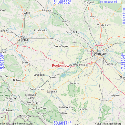
Kostomłoty GPS coordinates[2]
51° 2' 45.132" North, 16° 36' 37.836" East
| Map corner | latitude | longitude |
|---|---|---|
| Upper-left | 51.48582°, | 15.90739° |
| Center: | 51.04587°, | 16.61051° |
| Lower-right: | 50.60171°, | 17.31364° |
| Map W x H: | 98.3×98.3 km | = 61.1×61.1mi |
| max Lat: | 54.83135° ⇑54% North |
| Kostomłoty: | 51.04587° |
| min Lat: | ⇓46% South 49.21328° |
| min Long | Kostomłoty | max Long |
| 14.20249° | 16.61051° | 24.03723° |
| W 11.3%⇐ | ⇒88.7% E |
Elevation
Elevation of Kostomłoty is 167 m = 548 ft, and this is 24.4 m = 80 ft below average elevation for this country.
| Max E: |
974 m = 3196 ft | 51.9% |
| Avg. | 191.4 m = 628 ft | |
| Kostomłoty | 167 m = 548 ft | |
Min E: |
-3 m = -10 ft | 48.1% |
See also: Poland elevation on elevation.city.
Geographical zone
Kostomłoty is located in North temperate zone (between Tropic of Cancer and the Arctic Circle). Distance of this North polar circle is 1725.4 km =1072.1 mi to North.| Distance of | km | miles | from Kostomłoty |
|---|---|---|---|
| North Pole | 4331.3 | 2691.3 | to North |
| Arctic Circle | 1725.4 | 1072.1 | to North |
| Tropic Cancer | 3069.8 | 1907.5 | to South |
| Equator | 5675.8 | 3526.8 | to South |


Nearby cities:
15 places around Kostomłoty: (largest is in red/bold)
• Ciechów
10.1 km =6.3 mi,  342°
342°
• Gniechowice
16.9 km =10.5 mi,  112°
112°
• Konary
15.3 km =9.5 mi,  267°
267°
• Kąty Wrocławskie
11.1 km =6.9 mi,  98°
98°
• Lutynia
15.7 km =9.8 mi,  50°
50°
• Marcinowice
18.5 km =11.5 mi,  185°
185°
• Małkowice
15.2 km =9.4 mi,  76°
76°
• Miękinia
18.1 km =11.2 mi,  28°
28°
• Pietrzykowice
18.9 km =11.7 mi,  86°
86°
• Smolec
19.2 km =11.9 mi, 80°
• Sobótka
18.7 km =11.6 mi,  149°
149°
• Szczepanów
16.9 km =10.5 mi,  0°
0°
• Udanin
10.9 km =6.8 mi, 265°
• Środa Śląska
13.2 km =8.2 mi,  355°
355°
• Żarów
14.2 km =8.8 mi,  214°
214°
Sources, notices
• [Note1] Compared only with cities in Poland existing in our database
• [Src1] Map data: © OpenStreetMap contributors (CC-BY-SA)
• [Src2] Other city data from geonames.org with taken over terms of usage.
• [Src3] Geographical zone / Annual Mean Temperature by Robert A. Rohde @ Wikipedia
