Sułów geodata
Sułów (Lower Silesia) is a populated place; located in Poland in Europe/Warsaw (GMT+2) time zone. With population of 1,405 people, there are 1950 cities with bigger population in this country. Compared to other cities in Poland, 56.3% of cities are located further ↓South; 82.5% of cities are located further →East and 77.2% of cities have higher elevation than Sułów. Note1


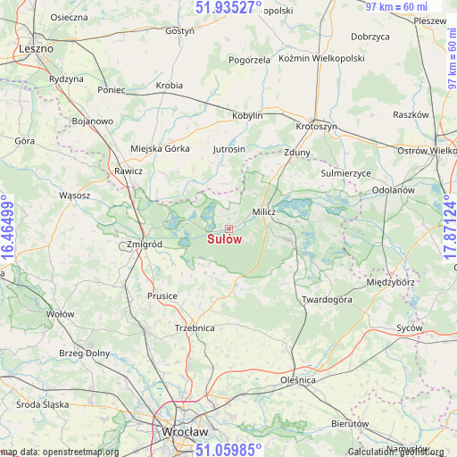
Sułów GPS coordinates[2]
51° 29' 58.776" North, 17° 10' 5.196" East
| Map corner | latitude | longitude |
|---|---|---|
| Upper-left | 51.93527°, | 16.46499° |
| Center: | 51.49966°, | 17.16811° |
| Lower-right: | 51.05985°, | 17.87124° |
| Map W x H: | 97.3×97.3 km | = 60.5×60.5mi |
| max Lat: | 54.83135° ⇑43.7% North |
| Sułów: | 51.49966° |
| min Lat: | ⇓56.3% South 49.21328° |
| min Long | Sułów | max Long |
| 14.20249° | 17.16811° | 24.03723° |
| W 17.5%⇐ | ⇒82.5% E |
Elevation
Elevation of Sułów is 105 m = 344 ft, and this is 86.4 m = 283 ft below average elevation for this country.
| Max E: |
974 m = 3196 ft | 77.2% |
| Avg. | 191.4 m = 628 ft | |
| Sułów | 105 m = 344 ft | |
Min E: |
-3 m = -10 ft | 22.8% |
See also: Poland elevation on elevation.city.
Geographical zone
Sułów is located in North temperate zone (between Tropic of Cancer and the Arctic Circle). Distance of this North polar circle is 1674.9 km =1040.7 mi to North.| Distance of | km | miles | from Sułów |
|---|---|---|---|
| North Pole | 4280.8 | 2660 | to North |
| Arctic Circle | 1674.9 | 1040.7 | to North |
| Tropic Cancer | 3120.3 | 1938.9 | to South |
| Equator | 5726.2 | 3558.1 | to South |


Nearby cities:
15 places around Sułów: (largest is in red/bold)
• Chojno
17.8 km =11.1 mi,  321°
321°
• Cieszków
19.6 km =12.2 mi,  41°
41°
• Dębno Polskie
22.1 km =13.7 mi,  295°
295°
• Jutrosin
16.7 km =10.4 mi,  0°
0°
• Konary
19.5 km =12.1 mi,  333°
333°
• Krośnice
13.5 km =8.4 mi,  101°
101°
• Milicz
7.8 km =4.8 mi,  66°
66°
• Pakosław
14.9 km =9.3 mi, 329°
• Prusice
20.3 km =12.6 mi,  225°
225°
• Szymanowo
22.3 km =13.9 mi, 301°
• Słupia Kapitulna
18.8 km =11.7 mi,  309°
309°
• Trzebnica
22.2 km =13.8 mi,  199°
199°
• Zawonia
20.5 km =12.7 mi,  174°
174°
• Zduny
21.7 km =13.5 mi, 41°
• Żmigród
18.5 km =11.5 mi,  258°
258°
Sources, notices
• [Note1] Compared only with cities in Poland existing in our database
• [Src1] Map data: © OpenStreetMap contributors (CC-BY-SA)
• [Src2] Other city data from geonames.org with taken over terms of usage.
• [Src3] Geographical zone / Annual Mean Temperature by Robert A. Rohde @ Wikipedia
