Janowo geodata
Janowo (Kujawsko-Pomorskie) is a populated place; located in Poland in Europe/Warsaw (GMT+2) time zone. With population of 750 people, there are 2953 cities with bigger population in this country. Compared to other cities in Poland, 85.5% of cities are located further ↓South; 50.4% of cities are located further ←West and 62.7% of cities have higher elevation than Janowo. Note1
Administrative division(s):
- Level 1: Kujawsko-Pomorskie
- Level 2: Powiat brodnicki
- Level 3: Świedziebnia


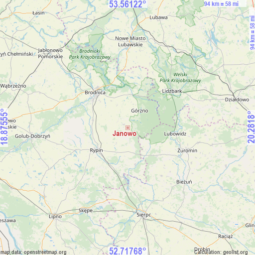
Janowo GPS coordinates[2]
53° 8' 29.472" North, 19° 34' 43.212" East
| Map corner | latitude | longitude |
|---|---|---|
| Upper-left | 53.56122°, | 18.87555° |
| Center: | 53.14152°, | 19.57867° |
| Lower-right: | 52.71768°, | 20.2818° |
| Map W x H: | 93.8×93.8 km | = 58.3×58.3mi |
| max Lat: | 54.83135° ⇑14.5% North |
| Janowo: | 53.14152° |
| min Lat: | ⇓85.5% South 49.21328° |
| min Long | Janowo | max Long |
| 14.20249° | 19.57867° | 24.03723° |
| W 50.4%⇐ | ⇒49.6% E |
Elevation
Elevation of Janowo is 140 m = 459 ft, and this is 51.4 m = 169 ft below average elevation for this country.
| Max E: |
974 m = 3196 ft | 62.7% |
| Avg. | 191.4 m = 628 ft | |
| Janowo | 140 m = 459 ft | |
Min E: |
-3 m = -10 ft | 37.3% |
See also: Poland elevation on elevation.city.
Geographical zone
Janowo is located in North temperate zone (between Tropic of Cancer and the Arctic Circle). Distance of this North polar circle is 1492.4 km =927.3 mi to North.| Distance of | km | miles | from Janowo |
|---|---|---|---|
| North Pole | 4098.3 | 2546.6 | to North |
| Arctic Circle | 1492.4 | 927.3 | to North |
| Tropic Cancer | 3302.9 | 2052.3 | to South |
| Equator | 5908.8 | 3671.6 | to South |


Nearby cities:
15 places around Janowo: (largest is in red/bold)
• Bartniczka
11.9 km =7.4 mi,  8°
8°
• Brodnica
17.9 km =11.1 mi,  317°
317°
• Brzozie
20.5 km =12.7 mi,  4°
4°
• Górzno
7.6 km =4.7 mi,  34°
34°
• Lidzbark
21.3 km =13.2 mi,  50°
50°
• Lubowidz
18 km =11.2 mi,  98°
98°
• Lutocin
21.8 km =13.5 mi,  144°
144°
• Osiek
13.2 km =8.2 mi,  283°
283°
• Ostrowite
20.7 km =12.9 mi,  247°
247°
• Rogowo
22.4 km =13.9 mi,  215°
215°
• Rypin
14.1 km =8.8 mi,  233°
233°
• Skrwilno
14.3 km =8.9 mi,  167°
167°
• Szczutowo
22.4 km =13.9 mi,  180°
180°
• Wąpielsk
20.1 km =12.5 mi,  268°
268°
• Świedziebnia
2 km =1.2 mi,  306°
306°
Sources, notices
• [Note1] Compared only with cities in Poland existing in our database
• [Src1] Map data: © OpenStreetMap contributors (CC-BY-SA)
• [Src2] Other city data from geonames.org with taken over terms of usage.
• [Src3] Geographical zone / Annual Mean Temperature by Robert A. Rohde @ Wikipedia
